
Carte topographique Lac-Sainte-Marie
Carte interactive
Cliquez sur la carte pour afficher l’altitude.
À propos de cette carte
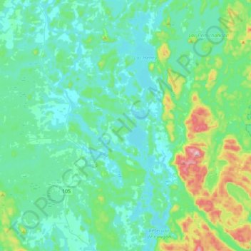
Nom : Carte topographique Lac-Sainte-Marie, altitude, relief.
Altitude moyenne : 206 m
Altitude minimum : 136 m
Altitude maximum : 546 m
Autres cartes topographiques
Cliquez sur une carte pour visualiser sa topographie, son altitude et son relief.
Lac d'une Rive à l'Autre
Canada > Québec > La Vallée-de-la-Gatineau > Lac-Lenôtre
Lac d'une Rive à l'Autre, Lac-Lenôtre, La Vallée-de-la-Gatineau, Outaouais, Québec, Canada
Altitude moyenne : 394 m
Bois-Franc
Canada > Québec > La Vallée-de-la-Gatineau
Bois-Franc, La Vallée-de-la-Gatineau, Outaouais, Québec, Canada
Altitude moyenne : 205 m
Lac Cellier
Canada > Québec > La Vallée-de-la-Gatineau > Lac-Pythonga
Lac Cellier, Lac-Pythonga, La Vallée-de-la-Gatineau, Outaouais, Québec, Canada
Altitude moyenne : 375 m
Kitigan Zibi Anishinabeg
Canada > Québec > La Vallée-de-la-Gatineau > Montcerf-Lytton
Kitigan Zibi Anishinabeg, Montcerf-Lytton, La Vallée-de-la-Gatineau, Outaouais, Québec, J9E 2V4, Canada
Altitude moyenne : 225 m
Kazabazua
Canada > Québec > La Vallée-de-la-Gatineau
Kazabazua, La Vallée-de-la-Gatineau, Outaouais, Québec, J0X 1X0, Canada
Altitude moyenne : 178 m
Rivière du Coucou
Canada > Québec > La Vallée-de-la-Gatineau > Lac-Moselle
Rivière du Coucou, Lac-Moselle, La Vallée-de-la-Gatineau, Outaouais, Québec, Canada
Altitude moyenne : 396 m
Lac Grey
Canada > Québec > La Vallée-de-la-Gatineau > Lac-Pythonga
Lac Grey, Lac-Pythonga, La Vallée-de-la-Gatineau, Outaouais, Québec, Canada
Altitude moyenne : 387 m
Lac du Castor Blanc
Canada > Québec > La Vallée-de-la-Gatineau > Aumond
Lac du Castor Blanc, Aumond, La Vallée-de-la-Gatineau, Outaouais, Québec, Canada
Altitude moyenne : 251 m
Lac du Camp
Canada > Québec > La Vallée-de-la-Gatineau > Aumond
Lac du Camp, Aumond, La Vallée-de-la-Gatineau, Outaouais, Québec, Canada
Altitude moyenne : 284 m
Lac Bow
Canada > Québec > La Vallée-de-la-Gatineau > Lac-Pythonga
Lac Bow, Lac-Pythonga, La Vallée-de-la-Gatineau, Outaouais, Québec, Canada
Altitude moyenne : 389 m
Lac Tarse
Canada > Québec > La Vallée-de-la-Gatineau > Lac-Pythonga
Lac Tarse, Lac-Pythonga, La Vallée-de-la-Gatineau, Outaouais, Québec, Canada
Altitude moyenne : 279 m
Déléage
Canada > Québec > La Vallée-de-la-Gatineau > Déléage
Déléage, La Vallée-de-la-Gatineau, Outaouais, Québec, J9E 2V9, Canada
Altitude moyenne : 195 m
Lac Chalain
Canada > Québec > La Vallée-de-la-Gatineau > Lac-Pythonga
Lac Chalain, Lac-Pythonga, La Vallée-de-la-Gatineau, Outaouais, Québec, Canada
Altitude moyenne : 384 m