
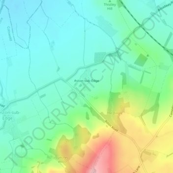
Carte topographique Aston Subedge
Carte interactive
Cliquez sur la carte pour afficher l’altitude.
À propos de cette carte
Nom : Carte topographique Aston Subedge, altitude, relief.
Altitude moyenne : 101 m
Altitude minimum : 52 m
Altitude maximum : 223 m
Autres cartes topographiques
Cliquez sur une carte pour visualiser sa topographie, son altitude et son relief.
Cutsdean
United Kingdom > England > Gloucestershire > Cotswold District
Cutsdean, Cotswold District, Gloucestershire, England, United Kingdom
Altitude moyenne : 233 m
Dowdeswell
United Kingdom > England > Gloucestershire > Cotswold District
Dowdeswell, Cotswold District, Gloucestershire, England, United Kingdom
Altitude moyenne : 209 m
Daylesford
United Kingdom > England > Gloucestershire > Cotswold District
Daylesford, Cotswold District, Gloucestershire, England, GL56 0YG, United Kingdom
Altitude moyenne : 137 m
Barnsley
United Kingdom > England > Gloucestershire > Cotswold District
Barnsley, Cotswold District, Gloucestershire, England, GL7 5EF, United Kingdom
Altitude moyenne : 135 m
Maugersbury
United Kingdom > England > Gloucestershire > Cotswold District
Maugersbury, Cotswold District, Gloucestershire, England, GL54 1HR, United Kingdom
Altitude moyenne : 166 m
Tarlton
United Kingdom > England > Gloucestershire > Cotswold District
Tarlton, Rodmarton, Cotswold District, Gloucestershire, England, GL7 6PA, United Kingdom
Altitude moyenne : 144 m
Duntisbourne Abbots
United Kingdom > England > Gloucestershire > Cotswold District
Duntisbourne Abbots, Cotswold District, Gloucestershire, England, GL7 7JN, United Kingdom
Altitude moyenne : 204 m
Bagpath
United Kingdom > England > Gloucestershire > Cotswold District
Bagpath, Kingscote, Cotswold District, Gloucestershire, England, GL8 8YG, United Kingdom
Altitude moyenne : 198 m
Cerney Wick
United Kingdom > England > Gloucestershire > Cotswold District
Cerney Wick, Cotswold District, Gloucestershire, England, GL7 5QH, United Kingdom
Altitude moyenne : 85 m
Birdlip
United Kingdom > England > Gloucestershire > Cotswold District
Birdlip, Cotswold District, Gloucestershire, England, United Kingdom
Altitude moyenne : 261 m
Worcestershire (detached)
United Kingdom > England > Gloucestershire > Cotswold District
Worcestershire (detached), Cotswold District, Gloucestershire, West Midlands Combined Authority, England, United Kingdom
Altitude moyenne : 103 m
Syde
United Kingdom > England > Gloucestershire > Cotswold District
Syde, Cotswold District, Gloucestershire, England, GL53 9PN, United Kingdom
Altitude moyenne : 238 m
Mickleton
United Kingdom > England > Gloucestershire > Cotswold District
Mickleton, Cotswold District, Gloucestershire, England, GL55 6TS, United Kingdom
Altitude moyenne : 101 m
Taylors Hill
United Kingdom > England > Gloucestershire > Cotswold District
Taylors Hill, Cotswold District, Gloucestershire, England, GL54 4BJ, United Kingdom
Altitude moyenne : 237 m
Cirencester
United Kingdom > England > Gloucestershire > Cotswold District > Chesterton
Cirencester, Chesterton, Cotswold District, Gloucestershire, England, United Kingdom
Altitude moyenne : 128 m
Trewsbury Mead
United Kingdom > England > Gloucestershire > Cotswold District
Trewsbury Mead, Coates, Cotswold District, Gloucestershire, England, GL7 6NY, United Kingdom
Altitude moyenne : 122 m
Hatherop
United Kingdom > England > Gloucestershire > Cotswold District
Hatherop, Cotswold District, Gloucestershire, England, GL7 3NA, United Kingdom
Altitude moyenne : 120 m
North Cerney
United Kingdom > England > Gloucestershire > Cotswold District
North Cerney, Cotswold District, Gloucestershire, England, GL7 7BZ, United Kingdom
Altitude moyenne : 179 m
Stow-on-the-Wold
United Kingdom > England > Gloucestershire > Cotswold District
Stow-on-the-Wold, Cotswold District, Gloucestershire, England, GL54 1AB, United Kingdom
Altitude moyenne : 163 m
Botany Bay Wood
United Kingdom > England > Gloucestershire > Cotswold District > Stow-on-the-Wold
Botany Bay Wood, Maugersbury, Stow-on-the-Wold, Cotswold District, Gloucestershire, England, United Kingdom
Altitude moyenne : 171 m
Eastleach Martin
United Kingdom > England > Gloucestershire > Cotswold District > Eastleach Turville
Eastleach Martin, Eastleach, Eastleach Turville, Cotswold District, Gloucestershire, England, GL7 3NW, United Kingdom
Altitude moyenne : 111 m
Saintbury
United Kingdom > England > Gloucestershire > Cotswold District
Saintbury, Cotswold District, Gloucestershire, England, WR12 7PX, United Kingdom
Altitude moyenne : 124 m
Coberley
United Kingdom > England > Gloucestershire > Cotswold District
Coberley, Cotswold District, Gloucestershire, England, GL53 9QZ, United Kingdom
Altitude moyenne : 240 m
Somerford Keynes
United Kingdom > England > Gloucestershire > Cotswold District
Somerford Keynes, Cotswold District, Gloucestershire, England, GL7 6DR, United Kingdom
Altitude moyenne : 91 m
Lechlade
United Kingdom > England > Gloucestershire > Cotswold District
Lechlade, Cotswold District, Gloucestershire, England, GL7 3BY, United Kingdom
Altitude moyenne : 81 m
Naunton
United Kingdom > England > Gloucestershire > Cotswold District
Naunton, Cotswold District, Gloucestershire, England, GL54 3AS, United Kingdom
Altitude moyenne : 201 m
Chipping Campden
United Kingdom > England > Gloucestershire > Cotswold District
Chipping Campden, Cotswold District, Gloucestershire, England, United Kingdom
Altitude moyenne : 191 m
Knap House Quarry, Birdlip
United Kingdom > England > Gloucestershire > Cotswold District > Birdlip
Knap House Quarry, Birdlip, Cowley, Birdlip, Cotswold District, Gloucestershire, England, United Kingdom
Altitude moyenne : 222 m
Withington
United Kingdom > England > Gloucestershire > Cotswold District
Withington, Cotswold District, Gloucestershire, England, United Kingdom
Altitude moyenne : 212 m
Down Ampney
United Kingdom > England > Gloucestershire > Cotswold District
Down Ampney, Cotswold District, Gloucestershire, England, GL7 5QR, United Kingdom
Altitude moyenne : 85 m
South Cerney
United Kingdom > England > Gloucestershire > Cotswold District > South Cerney
South Cerney, Cotswold District, Gloucestershire, England, United Kingdom
Altitude moyenne : 93 m
Weston-sub-Edge
United Kingdom > England > Gloucestershire > Cotswold District
Weston-sub-Edge, Cotswold District, Gloucestershire, England, GL55 6QZ, United Kingdom
Altitude moyenne : 98 m
Compton Abdale
United Kingdom > England > Gloucestershire > Cotswold District
Compton Abdale, Cotswold District, Gloucestershire, England, GL54 4DS, United Kingdom
Altitude moyenne : 212 m
Broad Campden
United Kingdom > England > Gloucestershire > Cotswold District
Broad Campden, Cotswold District, Gloucestershire, England, GL55 6UU, United Kingdom
Altitude moyenne : 167 m
Paxford
United Kingdom > England > Gloucestershire > Cotswold District > Paxford
Paxford, Cotswold District, Gloucestershire, England, GL55 6XW, United Kingdom
Altitude moyenne : 124 m
Upper Oddington
United Kingdom > England > Gloucestershire > Cotswold District
Upper Oddington, Cotswold District, Gloucestershire, England, GL56 0XH, United Kingdom
Altitude moyenne : 134 m
Tetbury
United Kingdom > England > Gloucestershire > Cotswold District
Tetbury, Cotswold District, Gloucestershire, England, United Kingdom
Altitude moyenne : 122 m
Winstone
United Kingdom > England > Gloucestershire > Cotswold District > Winstone
Winstone, Cotswold District, Gloucestershire, England, GL7 7JX, United Kingdom
Altitude moyenne : 222 m
Ampney Crucis
United Kingdom > England > Gloucestershire > Cotswold District
Ampney Crucis, Cotswold District, Gloucestershire, England, GL7 5SD, United Kingdom
Altitude moyenne : 114 m
Moreton-in-Marsh
United Kingdom > England > Gloucestershire > Cotswold District
Moreton-in-Marsh, Cotswold District, Gloucestershire, England, United Kingdom
Altitude moyenne : 135 m
Shorncote
United Kingdom > England > Gloucestershire > Cotswold District
Shorncote, Somerford Keynes, Cotswold District, Gloucestershire, England, GL7 6DE, United Kingdom
Altitude moyenne : 96 m
Aldsworth
United Kingdom > England > Gloucestershire > Cotswold District
Aldsworth, Cotswold District, Gloucestershire, England, GL54 3QX, United Kingdom
Altitude moyenne : 142 m
Bledington
United Kingdom > England > Gloucestershire > Cotswold District > Bledington
Bledington, Cotswold District, Gloucestershire, South West England, England, OX7 6XQ, United Kingdom
Altitude moyenne : 118 m
Fairford
United Kingdom > England > Gloucestershire > Cotswold District
Fairford, Cotswold District, Gloucestershire, England, United Kingdom
Altitude moyenne : 98 m
Northleach
United Kingdom > England > Gloucestershire > Cotswold District
Northleach, Cotswold District, Gloucestershire, England, GL54 3EE, United Kingdom
Altitude moyenne : 179 m
Ablington
United Kingdom > England > Gloucestershire > Cotswold District > Ablington
Ablington, Cotswold District, Gloucestershire, South West England, England, GL7 5NY, United Kingdom
Altitude moyenne : 136 m
Meysey Hampton
United Kingdom > England > Gloucestershire > Cotswold District > Meysey Hampton
Meysey Hampton, Cotswold District, Gloucestershire, South West England, England, GL7 5JT, United Kingdom
Altitude moyenne : 96 m
Bibury
United Kingdom > England > Gloucestershire > Cotswold District
Bibury, Cotswold District, Gloucestershire, England, United Kingdom
Altitude moyenne : 135 m
Cold Aston
United Kingdom > England > Gloucestershire > Cotswold District
Cold Aston, Cotswold District, Gloucestershire, England, GL54 3BN, United Kingdom
Altitude moyenne : 197 m
Blockley
United Kingdom > England > Gloucestershire > Cotswold District
Blockley, Cotswold District, Gloucestershire, England, United Kingdom
Altitude moyenne : 163 m