
Carte topographique Bihar
Carte interactive
Cliquez sur la carte pour afficher l’altitude.
À propos de cette carte
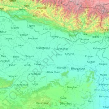
Nom : Carte topographique Bihar, altitude, relief.
Lieu : Bihar, India (24.28572 83.32126 27.52164 88.29823)
Altitude moyenne : 606 m
Altitude minimum : 11 m
Altitude maximum : 8 419 m
Bihar covers a total area of 94,163 km2 (36,357 sq mi), with an average elevation above sea level of 173 feet (53 m). It is land locked by Nepal in the north, Jharkhand in the south West Bengal in the east and Uttar Pradesh to the west. It has three parts on the basis of physical and structural conditions: the Southern Plateau, the Shivalik Region, and Bihar's Gangetic Plain. Furthermore, the vast stretch of fertile Bihar Plain is divided by the Ganges River into two unequal parts – North Bihar and South Bihar. The Ganges flows west–east and, along with its tributaries, regularly floods parts of the Bihar plain. The main northern tributaries are the Gandak and Koshi, which originate in the Nepalese Himalayas, and the Bagmati, which originates in the Kathmandu Valley. Other tributaries are the Son, Budhi Gandak, Chandan, Orhani and Phalgu. Bihar has some small hills, such as the Rajgir hills in center, Kaimur Range in south-west and Shivalik Range in North. Bihar has notified forest area of 6,764.14 km2, which is 7.1 percent of its geographical area. The sub-Himalayan foothills of Shivalik ranges, primary Someshwar and Dun mountain, in West Champaran district are clad in a belt of moist deciduous forest. As well as trees, this consists of scrub, grass and reeds.
Autres cartes topographiques
Cliquez sur une carte pour visualiser sa topographie, son altitude et son relief.
Nava Raipur
India > Chhattisgarh > Arang Tahsil
Nava Raipur, Arang Tahsil, Raipur District, Chhattisgarh, India
Altitude moyenne : 305 m
Baba Bakala Tahsil
Baba Bakala Tahsil, Amritsar District, Punjab, India
Altitude moyenne : 239 m
Ponneri
India > Tamil Nadu > Ponneri
Ponneri, Thiruvallur District, Tamil Nadu, 601204, India
Altitude moyenne : 10 m
Visakhapatnam
India > Andhra Pradesh > Visakhapatnam (Urban)
Visakhapatnam, Visakhapatnam (Urban), Visakhapatnam, Andhra Pradesh, 530001, India
Altitude moyenne : 41 m
Seelam Pur Tehsil
Seelam Pur Tehsil, North East Delhi District, Delhi, India
Altitude moyenne : 208 m
Gandhinagar
India > Gujarat > Gandhinagar Taluka
Gandhinagar, Gandhinagar Taluka, Gandhinagar District, Gujarat, India
Altitude moyenne : 75 m
Zemu Glacier
India > Sikkim > Chungthang
Zemu Glacier, Chungthang, Mangan District, Sikkim, India
Altitude moyenne : 5 510 m
Navi Mumbai
India > Maharashtra > Navi Mumbai
Navi Mumbai, Thane, Maharashtra, 400706, India
Altitude moyenne : 30 m
Rajkot
India > Gujarat > Rajkot Taluka
Rajkot, Rajkot Taluka, Rajkot District, Gujarat, 360001, India
Altitude moyenne : 141 m
Chikhli
India > Gujarat > Chikhli Taluka
Chikhli, Chikhli Taluka, Navsari District, Gujarat, 396521, India
Altitude moyenne : 23 m
Kaniyambādi
India > Tamil Nadu > Vellore
Kaniyambādi, Vellore, Vellore District, Tamil Nadu, 632102, India
Altitude moyenne : 253 m
Dudhsagar Falls
India > Goa > Dharbandora
Dudhsagar Falls, Dharbandora, South Goa District, Goa, India
Altitude moyenne : 418 m
Sahaspur
India > Uttar Pradesh > Dhampur
Sahaspur, Dhampur, Bijnor District, Uttar Pradesh, 246745, India
Altitude moyenne : 217 m
Lake Vasuki Tal
India > Uttarakhand > Ukhimath > Kedarnath
Lake Vasuki Tal, Kedarnath, Ukhimath, Rudraprayag District, Uttarakhand, India
Altitude moyenne : 4 303 m
Tiruchirappalli
India > Tamil Nadu > Tiruchirappalli
Tiruchirappalli, Tiruchchirappalli district, Tamil Nadu, 620001, India
Altitude moyenne : 83 m
Collem
India > Goa > Dharbandora
Collem, Dharbandora, South Goa District, Goa, India
Altitude moyenne : 90 m
Rajpura
India > Rajasthan > Shahpura Tehsil
Rajpura, Shahpura Tehsil, Jaipur(Rural) District, Rajasthan, 303103, India
Altitude moyenne : 451 m
Ognaj
India > Gujarat > Ghatlodiya Taluka
Ognaj, Ghatlodiya Taluka, Ahmedabad District, Gujarat, 380060, India
Altitude moyenne : 57 m
Pratapsinghpura
India > Rajasthan > Neemrana Tehsil
Pratapsinghpura, Neemrana Tehsil, Kotputli-Behror District, Rajasthan, 301706, India
Altitude moyenne : 309 m
Kanchipuram
India > Tamil Nadu > Kanchipuram
Kanchipuram, Kancheepuram, Kanchipuram District, Tamil Nadu, 631501, India
Altitude moyenne : 82 m
Ghatlodiya Taluka
Ghatlodiya Taluka, Ahmedabad District, Gujarat, India
Altitude moyenne : 53 m
Lucknow
India > Uttar Pradesh > Lucknow
Lucknow, Lucknow District, Uttar Pradesh, 226027, India
Altitude moyenne : 120 m
Yaja
India > Arunachal Pradesh > Taksing Circle
Yaja, Taksing Circle, Upper Subansiri District, Arunachal Pradesh, India
Altitude moyenne : 2 759 m
Burhanpur
Burhanpur, Azamgarh District, Uttar Pradesh, India
Altitude moyenne : 82 m
Nesari
India > Maharashtra > Gadhinglaj
Nesari, Gadhinglaj, Kolhapur, Maharashtra, 416504, India
Altitude moyenne : 730 m
Puducherry
India > Puducherry > Puducherry Taluk
Puducherry, Puducherry Taluk, Puducherry District, Puducherry, 605001, India
Altitude moyenne : 10 m
Mhasale
India > Maharashtra > Amalner
Mhasale, Amalner, Jalgaon, Maharashtra, 425105, India
Altitude moyenne : 196 m
Kanchanpur
Kanchanpur, Dasda, North Tripura District, Tripura, 799270, India
Altitude moyenne : 66 m
Kanchanpura
India > Madhya Pradesh > Batiyagarh Tahsil
Kanchanpura, Batiyagarh Tahsil, Damoh District, Madhya Pradesh, India
Altitude moyenne : 354 m
Kintada Kotapadu
India > Andhra Pradesh > K.Kotapadu
Kintada Kotapadu, K.Kotapadu, Anakapalli, Andhra Pradesh, 531034, India
Altitude moyenne : 82 m
Tikamsingh ki Dhani
India > Rajasthan > Dechoo Tehsil
Tikamsingh ki Dhani, Dechoo Tehsil, Phalodi District, Rajasthan, India
Altitude moyenne : 285 m
Biaora
India > Madhya Pradesh > Biaora Tahsil > Habirpura
Biaora, Habirpura, Biaora Tahsil, Rajgarh District, Madhya Pradesh, 465674, India
Altitude moyenne : 429 m
Ambala
India > Haryana > Ambala Cantt
Ambala, Ambala Cantt, Ambala District, Haryana, 134002, India
Altitude moyenne : 275 m
Umbraj
India > Maharashtra > Karad
Umbraj, Karad, Satara, Maharashtra, 415109, India
Altitude moyenne : 594 m
Laccadive Islands
India > Lakshadweep > Agatti > Agatti
Laccadive Islands, Agatti, Lakshadweep District, Lakshadweep, 262240, India
Altitude moyenne : 0 m
Ghatampur
India > Uttar Pradesh > Ghatampur
Ghatampur, Kanpur Nagar District, Uttar Pradesh, 209206, India
Altitude moyenne : 124 m
Tengha
India > Madhya Pradesh > Shahdol District
Tengha, Jaitpur Tahsil, Shahdol District, Madhya Pradesh, India
Altitude moyenne : 550 m
Tiruttani
India > Tamil Nadu > Tiruttani
Tiruttani, Thiruvallur District, Tamil Nadu, 631209, India
Altitude moyenne : 92 m
Natham
India > Tamil Nadu > Tiruttani
Natham, Tiruttani, Thiruvallur District, Tamil Nadu, 631209, India
Altitude moyenne : 108 m
Pudur
India > Tamil Nadu > Pallipattu
Pudur, Pallipattu, Thiruvallur District, Tamil Nadu, India
Altitude moyenne : 216 m