
Carte topographique Birchmoor
Carte interactive
Cliquez sur la carte pour afficher l’altitude.
À propos de cette carte
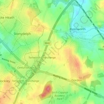
Nom : Carte topographique Birchmoor, altitude, relief.
Altitude moyenne : 93 m
Altitude minimum : 59 m
Altitude maximum : 139 m
Autres cartes topographiques
Cliquez sur une carte pour visualiser sa topographie, son altitude et son relief.
Pooley Country Park
United Kingdom > England > Warwickshire > North Warwickshire > Polesworth
Pooley Country Park, Shuttington CP, Polesworth, North Warwickshire, Warwickshire, West Midlands, England, United Kingdom
Altitude moyenne : 76 m