
Carte topographique Fontaine
Carte interactive
Cliquez sur la carte pour afficher l’altitude.
À propos de cette carte
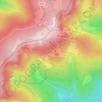
Nom : Carte topographique Fontaine, altitude, relief.
Altitude moyenne : 1 079 m
Altitude minimum : 761 m
Altitude maximum : 1 282 m
Autres cartes topographiques
Cliquez sur une carte pour visualiser sa topographie, son altitude et son relief.
Trois Fours
France > Grand Est > Haut-Rhin > Stosswihr
Trois Fours, Stosswihr, Colmar-Ribeauvillé, Haut-Rhin, Grand Est, France métropolitaine, 68140, France
Altitude moyenne : 1 037 m
Ampfersbach
France > Grand Est > Haut-Rhin > Stosswihr
Ampfersbach, Stosswihr, Colmar-Ribeauvillé, Haut-Rhin, Grand Est, France métropolitaine, 68140, France
Altitude moyenne : 634 m