
Carte topographique Cuneo
Carte interactive
Cliquez sur la carte pour afficher l’altitude.
À propos de cette carte
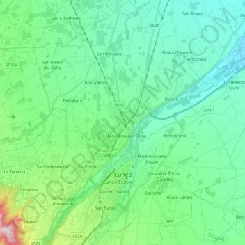
Nom : Carte topographique Cuneo, altitude, relief.
Lieu : Cuneo, Piemont, 12100, Italy (44.34828 7.47459 44.49092 7.64052)
Altitude moyenne : 510 m
Altitude minimum : 385 m
Altitude maximum : 1 010 m
Cuneo has a temperate sub-continental climate, with cold winters and hot, dry summers. However, it is situated more than 500 metres (1,640 feet) above sea level, which helps to make summers more bearable: the hottest month, July, has an average temperature of 21.6 °C (70.9 °F). The coldest, January, averages 1.7 °C (35.1 °F). Annual precipitation is about 962 mm (37.9 in), distributed over 81 days. The rainfall pattern is similar to that of Turin, with two maxima—one primary and one secondary (spring and autumn) and two minima (summer and winter). The driest month is July, 44 millimetres (1.7 in). Snowfalls are frequent owing to high elevation and wind patterns.