
Carte topographique Innsbruck
Carte interactive
Cliquez sur la carte pour afficher l’altitude.
À propos de cette carte
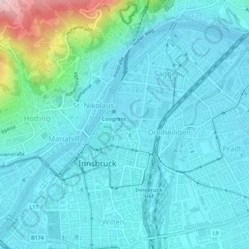
Nom : Carte topographique Innsbruck, altitude, relief.
Lieu : Innsbruck, Statutarstadt Innsbruck, Tyrol, Autriche (47.25837 11.38119 47.28086 11.41818)
Altitude moyenne : 611 m
Altitude minimum : 567 m
Altitude maximum : 878 m
La ville est située entre le massif Karwendel au nord et les premiers contreforts de la chaîne centrale des Alpes (Patscherkofel) au sud, à une altitude de 574 m.
Autres cartes topographiques
Cliquez sur une carte pour visualiser sa topographie, son altitude et son relief.