
Carte topographique Dodge City
Carte interactive
Cliquez sur la carte pour afficher l’altitude.
À propos de cette carte
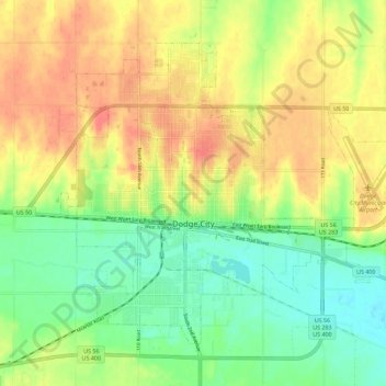
Nom : Carte topographique Dodge City, altitude, relief.
Lieu : Dodge City, Ford County, Kansas, 67801, United States (37.72492 -100.05593 37.79469 -99.94277)
Altitude moyenne : 777 m
Altitude minimum : 747 m
Altitude maximum : 809 m
Dodge City is located at 37°45′35″N 100°1′6″W / 37.75972°N 100.01833°W / 37.75972; -100.01833 (37.759671, −100.018212) at an elevation of 2,493 ft (760 m). It lies on the Arkansas River in the High Plains region of the Great Plains. The city sits above one of the world's largest underground water systems, the Ogallala Aquifer, and is 25 miles (40 km) from the eastern edge of the Hugoton Natural Gas Area. Located at the intersection of U. S. Routes 50, 56 and 283 in southwestern Kansas, Dodge City is 151 mi (243 km) west of Wichita, 199 mi (320 km) northeast of Amarillo, and 301 mi (484 km) southeast of Denver.
Autres cartes topographiques
Cliquez sur une carte pour visualiser sa topographie, son altitude et son relief.
Dodge City
United States > Kansas > Ford County > Dodge City > Dodge City
Dodge City, Ford County, Kansas, 67801, United States
Altitude moyenne : 779 m