
Carte topographique Dead Women Crossing
Carte interactive
Cliquez sur la carte pour afficher l’altitude.
À propos de cette carte
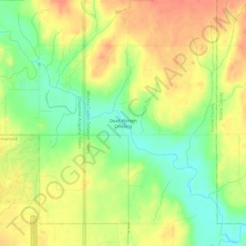
Nom : Carte topographique Dead Women Crossing, altitude, relief.
Lieu : Dead Women Crossing, Custer County, Oklahoma, United States (35.54783 -98.67091 35.58783 -98.63091)
Altitude moyenne : 482 m
Altitude minimum : 455 m
Altitude maximum : 504 m
Dead Women Crossing, also known as Dead Woman's Crossing, is an unincorporated community on Deer Creek northeast of Weatherford in Custer County, Oklahoma, United States, at an elevation of 1,509 feet (460 m). The community takes its name from the unsolved murder of a local woman.
Autres cartes topographiques
Cliquez sur une carte pour visualiser sa topographie, son altitude et son relief.
Clinton
United States > Oklahoma > Custer County
Clinton, Custer County, Oklahoma, 73601, United States
Altitude moyenne : 481 m