
Carte topographique Castlewellan Forest Park
Carte interactive
Cliquez sur la carte pour afficher l’altitude.
À propos de cette carte
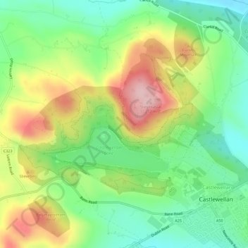
Nom : Carte topographique Castlewellan Forest Park, altitude, relief.
Altitude moyenne : 145 m
Altitude minimum : 63 m
Altitude maximum : 265 m
Autres cartes topographiques
Cliquez sur une carte pour visualiser sa topographie, son altitude et son relief.
Slievenaslat
United Kingdom > Northern Ireland > Castlewellan
Slievenaslat, Castlewellan, County Down, Northern Ireland, BT31 9SQ, United Kingdom
Altitude moyenne : 142 m