
Carte topographique The Dalles
Carte interactive
Cliquez sur la carte pour afficher l’altitude.
À propos de cette carte
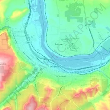
Nom : Carte topographique The Dalles, altitude, relief.
Lieu : The Dalles, Wasco County, Oregon, United States (45.58517 -121.22910 45.64030 -121.12104)
Altitude moyenne : 105 m
Altitude minimum : 18 m
Altitude maximum : 343 m
As in the summer, winter temperatures can vary tremendously from one day to the next. During arctic air events the daytime high temperatures will generally be well below 32 °F or 0 °C, while a strong subtropical push can raise temperatures into the 50s and low 60s F, even in January. It is quite common for relatively cold air to become trapped at low elevations due to an inversion above; depending on the temperature of the surface airmass, depth of the inversion layer, and temperatures above the inversion layer, this can result in snow, sleet, freezing rain or a very cold liquid rain.
Autres cartes topographiques
Cliquez sur une carte pour visualiser sa topographie, son altitude et son relief.
Maupin
United States > Oregon > Wasco County
Maupin, Wasco County, Oregon, United States
Altitude moyenne : 368 m
Dufur
United States > Oregon > Wasco County
Dufur, Wasco County, Oregon, 97021, United States
Altitude moyenne : 445 m