
Carte topographique Dotty Lake
Carte interactive
Cliquez sur la carte pour afficher l’altitude.
À propos de cette carte
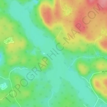
Nom : Carte topographique Dotty Lake, altitude, relief.
Altitude moyenne : 403 m
Altitude minimum : 363 m
Altitude maximum : 461 m
Autres cartes topographiques
Cliquez sur une carte pour visualiser sa topographie, son altitude et son relief.
Ril Lake
Canada > Ontario > Lake of Bays Township > Lake of Bays
Ril Lake, South Ril Lake Road, Lake of Bays Township, District Municipality of Muskoka, Muskoka District, Central Ontario, Ontario, Canada
Altitude moyenne : 361 m
Dickie Lake
Canada > Ontario > Lake of Bays
Dickie Lake, Dickie Lake Road, Lake of Bays, District Municipality of Muskoka, Muskoka District, Central Ontario, Ontario, Canada
Altitude moyenne : 360 m
Oxbow Lake
Canada > Ontario > Lake of Bays
Oxbow Lake, East Oxbow Road, Lake of Bays, District Municipality of Muskoka, Muskoka District, Ontario, Canada
Altitude moyenne : 400 m
Grant Lake
Canada > Ontario > Lake of Bays
Grant Lake, Shoe Lake Road, Lake of Bays, District Municipality of Muskoka, Muskoka District, Ontario, P0A 1E0, Canada
Altitude moyenne : 384 m
Cream Lake
Canada > Ontario > Lake of Bays
Cream Lake, South Ril Lake Road, Lake of Bays, District Municipality of Muskoka, Muskoka District, Ontario, Canada
Altitude moyenne : 363 m
Menominee Lake
Canada > Ontario > Lake of Bays
Menominee Lake, Grand Boulevard, Lake of Bays, District Municipality of Muskoka, Muskoka District, Ontario, Canada
Altitude moyenne : 355 m
Porcupine Lake
Canada > Ontario > Lake of Bays
Porcupine Lake, South Ril Lake Road, Lake of Bays, District Municipality of Muskoka, Muskoka District, Ontario, Canada
Altitude moyenne : 361 m