
Carte topographique Blancs-Coteaux
Carte interactive
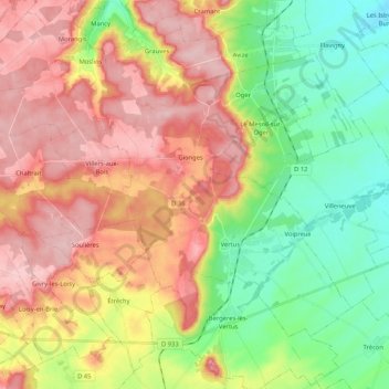
Cliquez sur la carte pour afficher l’altitude.
À propos de cette carte
Nom : Carte topographique Blancs-Coteaux, altitude, relief.
Altitude moyenne : 166 m
Altitude minimum : 84 m
Altitude maximum : 253 m
Autres cartes topographiques
Cliquez sur une carte pour visualiser sa topographie, son altitude et son relief.
Vertus
France > Grand Est > Marne > Blancs-Coteaux
Vertus, Blancs-Coteaux, Épernay, Marne, Grand Est, France métropolitaine, 51130, France
Altitude moyenne : 158 m
Oger
France > Grand Est > Marne > Blancs-Coteaux
Oger, Blancs-Coteaux, Épernay, Marne, Grand Est, France métropolitaine, 51190, France
Altitude moyenne : 164 m