
Carte topographique Le Champu
Carte interactive
Cliquez sur la carte pour afficher l’altitude.
À propos de cette carte
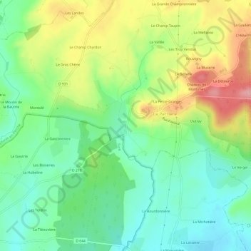
Nom : Carte topographique Le Champu, altitude, relief.
Altitude moyenne : 156 m
Altitude minimum : 107 m
Altitude maximum : 236 m
Autres cartes topographiques
Cliquez sur une carte pour visualiser sa topographie, son altitude et son relief.
Les Batailles
France > Normandie > Orne > Belforêt-en-Perche
Les Batailles, Le Gué-de-la-Chaîne, Belforêt-en-Perche, Mortagne-au-Perche, Orne, Normandie, France métropolitaine, 61130, France
Altitude moyenne : 184 m
Bouvigny
France > Normandie > Orne > Belforêt-en-Perche
Bouvigny, La Perrière, Belforêt-en-Perche, Mortagne-au-Perche, Orne, Normandie, France métropolitaine, 61360, France
Altitude moyenne : 179 m
Beau Repos
France > Normandie > Orne > Belforêt-en-Perche
Beau Repos, Eperrais, Belforêt-en-Perche, Mortagne-au-Perche, Orne, Normandie, France métropolitaine, 61400, France
Altitude moyenne : 180 m
Eperrais
France > Normandie > Orne > Belforêt-en-Perche
Eperrais, Belforêt-en-Perche, Mortagne-au-Perche, Orne, Normandie, France métropolitaine, 61400, France
Altitude moyenne : 189 m
Sérigny
France > Normandie > Orne > Belforêt-en-Perche
Sérigny, Belforêt-en-Perche, Mortagne-au-Perche, Orne, Normandie, France métropolitaine, 61130, France
Altitude moyenne : 196 m
La Petite Grange
France > Normandie > Orne > Belforêt-en-Perche
La Petite Grange, La Perrière, Belforêt-en-Perche, Mortagne-au-Perche, Orne, Normandie, France métropolitaine, 61360, France
Altitude moyenne : 167 m
La Perrière
France > Normandie > Orne > Belforêt-en-Perche
La Perrière, Belforêt-en-Perche, Mortagne-au-Perche, Orne, Normandie, France métropolitaine, 61360, France
Altitude moyenne : 174 m