
Carte topographique The Cotswolds National Landscape
Carte interactive
Cliquez sur la carte pour afficher l’altitude.
À propos de cette carte
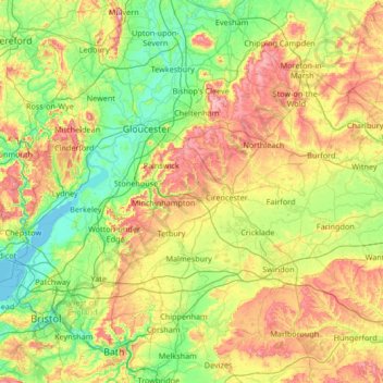
Nom : Carte topographique The Cotswolds National Landscape, altitude, relief.
Altitude moyenne : 109 m
Altitude minimum : 0 m
Altitude maximum : 369 m
Autres cartes topographiques
Cliquez sur une carte pour visualiser sa topographie, son altitude et son relief.
Cheltenham
United Kingdom > England > Gloucestershire
Cheltenham, Gloucestershire, England, United Kingdom
Altitude moyenne : 109 m
Gloucester
United Kingdom > England > Gloucestershire
Gloucester, Gloucestershire, England, United Kingdom
Altitude moyenne : 36 m
Cotswold District
United Kingdom > England > Gloucestershire
Cotswold District, Gloucestershire, England, United Kingdom
Altitude moyenne : 118 m
Stroud
United Kingdom > England > Gloucestershire
Stroud, Gloucestershire, England, United Kingdom
Altitude moyenne : 113 m
Aston Cross
United Kingdom > England > Gloucestershire > Tewkesbury
Aston Cross, Ashchurch Rural, Tewkesbury, Gloucestershire, England, GL20 8LN, United Kingdom
Altitude moyenne : 27 m
Sharpness
United Kingdom > England > Gloucestershire > Stroud
Sharpness, Stroud, Gloucestershire, England, GL13 9PE, United Kingdom
Altitude moyenne : 17 m
Forest of Dean District
United Kingdom > England > Gloucestershire
Forest of Dean District, Gloucestershire, England, United Kingdom
Altitude moyenne : 86 m
North Matson
United Kingdom > England > Gloucestershire > Gloucester
North Matson, Gloucester, Gloucestershire, England, United Kingdom
Altitude moyenne : 52 m
Newnham
United Kingdom > England > Gloucestershire > Forest of Dean
Newnham, Forest of Dean, Gloucestershire, England, United Kingdom
Altitude moyenne : 77 m
Cutsdean
United Kingdom > England > Gloucestershire > Cotswold District
Cutsdean, Cotswold District, Gloucestershire, England, United Kingdom
Altitude moyenne : 233 m
Dowdeswell
United Kingdom > England > Gloucestershire > Cotswold District
Dowdeswell, Cotswold District, Gloucestershire, England, United Kingdom
Altitude moyenne : 209 m
Charlton Kings
United Kingdom > England > Gloucestershire > Cheltenham
Charlton Kings, Cheltenham, Gloucestershire, England, GL53 8BB, United Kingdom
Altitude moyenne : 125 m
Daylesford
United Kingdom > England > Gloucestershire > Cotswold District
Daylesford, Cotswold District, Gloucestershire, England, GL56 0YG, United Kingdom
Altitude moyenne : 137 m
Barnsley
United Kingdom > England > Gloucestershire > Cotswold District
Barnsley, Cotswold District, Gloucestershire, England, GL7 5EF, United Kingdom
Altitude moyenne : 135 m
Maugersbury
United Kingdom > England > Gloucestershire > Cotswold District
Maugersbury, Cotswold District, Gloucestershire, England, GL54 1HR, United Kingdom
Altitude moyenne : 166 m
English Bicknor
United Kingdom > England > Gloucestershire > Forest of Dean
English Bicknor, Forest of Dean, Gloucestershire, England, GL16 7PQ, United Kingdom
Altitude moyenne : 122 m
Breadstone
United Kingdom > England > Gloucestershire > Stroud
Breadstone, Stroud, Gloucestershire, England, GL13 9HF, United Kingdom
Altitude moyenne : 27 m
Saul
United Kingdom > England > Gloucestershire > Stroud
Saul, Stroud, Gloucestershire, England, GL2 7LW, United Kingdom
Altitude moyenne : 12 m
Woolaston
United Kingdom > England > Gloucestershire > Forest of Dean
Woolaston, Forest of Dean, Gloucestershire, England, GL15 6QB, United Kingdom
Altitude moyenne : 70 m
Bream
United Kingdom > England > Gloucestershire > Forest of Dean
Bream, Forest of Dean, Gloucestershire, England, GL15 6LE, United Kingdom
Altitude moyenne : 122 m
Westrip
United Kingdom > England > Gloucestershire > Stroud > Randwick
Westrip, Randwick and Westrip, Randwick, Stroud, Gloucestershire, England, GL6 6HE, United Kingdom
Altitude moyenne : 82 m
Duntisbourne Abbots
United Kingdom > England > Gloucestershire > Cotswold District
Duntisbourne Abbots, Cotswold District, Gloucestershire, England, GL7 7JN, United Kingdom
Altitude moyenne : 204 m
Tarlton
United Kingdom > England > Gloucestershire > Cotswold District
Tarlton, Rodmarton, Cotswold District, Gloucestershire, England, GL7 6PA, United Kingdom
Altitude moyenne : 144 m
Bagpath
United Kingdom > England > Gloucestershire > Cotswold District
Bagpath, Kingscote, Cotswold District, Gloucestershire, England, GL8 8YG, United Kingdom
Altitude moyenne : 198 m
Slad
United Kingdom > England > Gloucestershire > Stroud
Slad, Stroud, Gloucestershire, England, GL6 7QA, United Kingdom
Altitude moyenne : 159 m
Great Witcombe
United Kingdom > England > Gloucestershire > Tewkesbury
Great Witcombe, Witcombe, Tewkesbury, Gloucestershire, England, United Kingdom
Altitude moyenne : 159 m
Brookend
United Kingdom > England > Gloucestershire > Stroud > Sharpness
Brookend, Hinton, Sharpness, Stroud, Gloucestershire, England, GL13 9SG, United Kingdom
Altitude moyenne : 18 m
Pamington
United Kingdom > England > Gloucestershire > Tewkesbury
Pamington, Ashchurch Rural, Tewkesbury, Gloucestershire, England, GL20 8LX, United Kingdom
Altitude moyenne : 27 m
Dymock
United Kingdom > England > Gloucestershire > Forest of Dean
Dymock, Forest of Dean, Gloucestershire, England, GL18 2AX, United Kingdom
Altitude moyenne : 50 m
Hewelsfield
United Kingdom > England > Gloucestershire > Forest of Dean District
Hewelsfield, Forest of Dean District, Gloucestershire, England, GL15 6UL, United Kingdom
Altitude moyenne : 161 m
Joyford
United Kingdom > England > Gloucestershire > Forest of Dean > Berry Hill
Joyford, West Dean, Berry Hill, Forest of Dean, Gloucestershire, England, GL16 7AH, United Kingdom
Altitude moyenne : 188 m
Bondend
United Kingdom > England > Gloucestershire > Stroud
Bondend, Upton St. Leonards, Stroud, Gloucestershire, England, GL4 8ED, United Kingdom
Altitude moyenne : 82 m
Cerney Wick
United Kingdom > England > Gloucestershire > Cotswold District
Cerney Wick, Cotswold District, Gloucestershire, England, GL7 5QH, United Kingdom
Altitude moyenne : 85 m
Aston on Carrant
United Kingdom > England > Gloucestershire > Tewkesbury
Aston on Carrant, Ashchurch Rural, Tewkesbury, Gloucestershire, England, GL20 8HL, United Kingdom
Altitude moyenne : 27 m
Birdlip
United Kingdom > England > Gloucestershire > Cotswold District
Birdlip, Cotswold District, Gloucestershire, England, United Kingdom
Altitude moyenne : 261 m
Hope Valley
United Kingdom > England > Gloucestershire > Forest of Dean > Lydney > Aylburton
Hope Valley, Lydney, Aylburton, Forest of Dean, Gloucestershire, England, GL15 6BT, United Kingdom
Altitude moyenne : 61 m
Fossil Beach
United Kingdom > England > Gloucestershire > Forest of Dean > Sedbury
Fossil Beach, Tidenham, Sedbury, Forest of Dean, Gloucestershire, England, NP16 7FD, United Kingdom
Altitude moyenne : 14 m
Worcestershire (detached)
United Kingdom > England > Gloucestershire > Cotswold District
Worcestershire (detached), Cotswold District, Gloucestershire, West Midlands Combined Authority, England, United Kingdom
Altitude moyenne : 103 m
Swifts Hill
United Kingdom > England > Gloucestershire > Stroud
Swifts Hill, Stroud, Gloucestershire, England, GL6 7LA, United Kingdom
Altitude moyenne : 184 m
Cam Long Down
United Kingdom > England > Gloucestershire > Dursley
Cam Long Down, Cam, Dursley, Stroud, Gloucestershire, England, GL11 5BQ, United Kingdom
Altitude moyenne : 111 m
Syde
United Kingdom > England > Gloucestershire > Cotswold District
Syde, Cotswold District, Gloucestershire, England, GL53 9PN, United Kingdom
Altitude moyenne : 238 m
Woodmancote
United Kingdom > England > Gloucestershire > Tewkesbury
Woodmancote, Tewkesbury, Gloucestershire, England, GL52 9QB, United Kingdom
Altitude moyenne : 135 m
Upleadon
United Kingdom > England > Gloucestershire > Forest of Dean
Upleadon, Forest of Dean, Gloucestershire, England, GL18 1EF, United Kingdom
Altitude moyenne : 33 m
Tewkesbury
United Kingdom > England > Gloucestershire > Tewkesbury
Tewkesbury, Gloucestershire, England, United Kingdom
Altitude moyenne : 18 m
Beeches
United Kingdom > England > Gloucestershire > Cheltenham > Charlton Kings
Beeches, Charlton Kings, Cheltenham, Gloucestershire, England, United Kingdom, Timbercombe
Altitude moyenne : 159 m
Mickleton
United Kingdom > England > Gloucestershire > Cotswold District
Mickleton, Cotswold District, Gloucestershire, England, GL55 6TS, United Kingdom
Altitude moyenne : 101 m
Taylors Hill
United Kingdom > England > Gloucestershire > Cotswold District
Taylors Hill, Cotswold District, Gloucestershire, England, GL54 4BJ, United Kingdom
Altitude moyenne : 237 m
White City
United Kingdom > England > Gloucestershire > Gloucester
White City, Gloucester, Gloucestershire, England, GL4 6UL, United Kingdom
Altitude moyenne : 38 m
Cirencester
United Kingdom > England > Gloucestershire > Cotswold District > Chesterton
Cirencester, Chesterton, Cotswold District, Gloucestershire, England, United Kingdom
Altitude moyenne : 128 m
Little Shurdington
United Kingdom > England > Gloucestershire > Tewkesbury > Bentham
Little Shurdington, Badgeworth, Bentham, Tewkesbury, Gloucestershire, England, GL51 4TX, United Kingdom
Altitude moyenne : 112 m