
Carte topographique Coos Bay
Carte interactive
Cliquez sur la carte pour afficher l’altitude.
À propos de cette carte
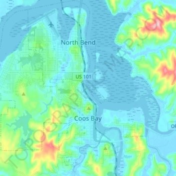
Nom : Carte topographique Coos Bay, altitude, relief.
Lieu : Coos Bay, Coos County, Oregon, 97420, United States (43.34296 -124.29044 43.42319 -124.16729)
Altitude moyenne : 30 m
Altitude minimum : -4 m
Altitude maximum : 209 m
According to the United States Census Bureau, the city has a total area of 15.90 square miles (41.18 km2), of which, 10.60 square miles (27.45 km2) is land and 5.30 square miles (13.73 km2) is water. The city is quite hilly, with elevations ranging from between sea level to over 500 feet (150 m). Bodies of water within the city limits include Upper Pony Creek Reservoir, Lake Merritt, Empire Lakes and numerous streams.
Autres cartes topographiques
Cliquez sur une carte pour visualiser sa topographie, son altitude et son relief.
Whiskey Run Beach
United States > Oregon > Coos County
Whiskey Run Beach, Coos County, Oregon, United States
Altitude moyenne : 22 m
Coquille
United States > Oregon > Coos County
Coquille, Coos County, Oregon, United States
Altitude moyenne : 40 m
North Bend
United States > Oregon > Coos County > North Bend
North Bend, Coos County, Oregon, United States
Altitude moyenne : 11 m
Bandon
United States > Oregon > Coos County
Bandon, Coos County, Oregon, United States
Altitude moyenne : 22 m