
Carte topographique Dagana
Carte interactive
Cliquez sur la carte pour afficher l’altitude.
À propos de cette carte
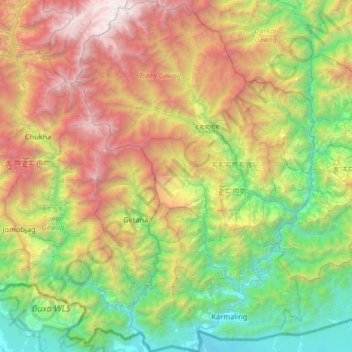
Nom : Carte topographique Dagana, altitude, relief.
Lieu : Dagana, Bhoutan (26.70169 89.63438 27.28202 90.07599)
Altitude moyenne : 1 699 m
Altitude minimum : 91 m
Altitude maximum : 4 678 m
Autres cartes topographiques
Cliquez sur une carte pour visualiser sa topographie, son altitude et son relief.
Radi
Bhoutan > Zhemgang > Shingkhar Gewog
Radi, Shingkhar Gewog, Zhemgang, Bhoutan
Altitude moyenne : 2 606 m
Thimphu Dzongkhag
Bhoutan > Punakha > Thimphu Dzongkhag
Thimphu Dzongkhag, Punakha, Bhoutan
Altitude moyenne : 3 553 m
Shari
Bhoutan > Haa > Shar-ri Chiwogs > Shari
Shari, Shar-ri Chiwogs, ས་དམར་ Samar Gewog, Haa, Bhoutan
Altitude moyenne : 2 893 m
Chomolhari Range
Chomolhari Range, Thimphou, Bhoutan
Altitude moyenne : 4 193 m