
Carte topographique Harford County
Carte interactive
Cliquez sur la carte pour afficher l’altitude.
À propos de cette carte
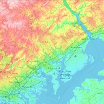
Nom : Carte topographique Harford County, altitude, relief.
Lieu : Harford County, Maryland, United States (39.25801 -76.56945 39.72121 -76.03564)
Altitude moyenne : 70 m
Altitude minimum : -3 m
Altitude maximum : 237 m
Harford County straddles the border between the rolling hills of the Piedmont Plateau and the flatlands of the Atlantic Coastal Plain along the Chesapeake Bay and its tributaries. The county's development is a mix of rural and suburban, with denser development in the larger towns of Aberdeen and Bel Air and along Route 40 and other major arteries leading out of Baltimore. The highest elevations are in the north and northwest of the county, reaching 805 ft. near the Pennsylvania border in the county's northwestern corner. The lowest elevation is sea level along the Chesapeake Bay.
Autres cartes topographiques
Cliquez sur une carte pour visualiser sa topographie, son altitude et son relief.
Middle East
United States > Maryland > Baltimore
Middle East, Baltimore, Maryland, United States
Altitude moyenne : 29 m
Annapolis
United States > Maryland > Anne Arundel County
Annapolis, Anne Arundel County, Maryland, United States
Altitude moyenne : 8 m
Baltimore
United States > Maryland > Baltimore
Baltimore, Maryland, 21233, United States
Altitude moyenne : 65 m
Frederick County
Frederick County, Maryland, United States
Altitude moyenne : 186 m
Rockville
United States > Maryland > Montgomery County
Rockville, Montgomery County, Maryland, United States
Altitude moyenne : 122 m
Old Colony
United States > Maryland > Charles County > La Plata
Old Colony, La Plata, Charles County, Maryland, 20646, United States
Altitude moyenne : 52 m
Ellicott City
United States > Maryland > Howard County
Ellicott City, Howard County, Maryland, 21043, United States
Altitude moyenne : 119 m
Highfield Park
United States > Maryland > Harford County > Bel Air
Highfield Park, Bel Air, Harford County, Maryland, United States
Altitude moyenne : 153 m
Prince George's County
Prince George's County, Maryland, United States
Altitude moyenne : 45 m
West Frederick Highlands
United States > Maryland > Frederick County > Ballenger Creek
West Frederick Highlands, Ballenger Creek, Frederick County, Maryland, 21703, United States
Altitude moyenne : 113 m
Salisbury
United States > Maryland > Wicomico County
Salisbury, Wicomico County, Maryland, United States
Altitude moyenne : 12 m
Centennial Lake
United States > Maryland > Howard County
Centennial Lake, Dorsey's Search, Howard County, Maryland, United States
Altitude moyenne : 116 m
Ridgely
United States > Maryland > Caroline County
Ridgely, Caroline County, Maryland, 21660, United States
Altitude moyenne : 18 m
Gist
United States > Maryland > Carroll County
Gist, Carroll County, Maryland, United States
Altitude moyenne : 203 m
Temple Hills
United States > Maryland > Prince George's County
Temple Hills, Prince George's County, Maryland, 20748, United States
Altitude moyenne : 66 m
Colt Terrace Neighborhood Park
United States > Maryland > Montgomery County > Silver Spring
Colt Terrace Neighborhood Park, 11400, Silver Spring, Montgomery County, Maryland, 20902, United States
Altitude moyenne : 119 m
Cecil Manor
United States > Maryland > Cecil County
Cecil Manor, Cecil County, Maryland, 21920, United States
Altitude moyenne : 44 m
Fox Field
United States > Maryland > Caroline County
Fox Field, Caroline County, Maryland, 21641, United States
Altitude moyenne : 15 m
Queensberry
United States > Maryland > Calvert County > Prince Frederick
Queensberry, Prince Frederick, Calvert County, Maryland, 20678, United States
Altitude moyenne : 37 m
Jersey Island
United States > Maryland > Somerset County > Crisfield
Jersey Island, Crisfield, Somerset County, Maryland, 21817, United States
Altitude moyenne : 2 m
Calvert Cliffs
United States > Maryland > Calvert County
Calvert Cliffs, Calvert County, Maryland, 20657, United States
Altitude moyenne : 11 m
Accident
United States > Maryland > Garrett County
Accident, Garrett County, Maryland, United States
Altitude moyenne : 751 m
Dundalk
United States > Maryland > Baltimore County
Dundalk, Baltimore County, Maryland, 21222, United States
Altitude moyenne : 33 m
Lutherville
United States > Maryland > Baltimore County
Lutherville, Baltimore County, Maryland, 21204, United States
Altitude moyenne : 117 m
Cumberland
United States > Maryland > Allegany County
Cumberland, Allegany County, Maryland, 21502, United States
Altitude moyenne : 264 m
Elkridge
United States > Maryland > Howard County
Elkridge, Howard County, Maryland, 21075, United States
Altitude moyenne : 39 m
Severn
United States > Maryland > Anne Arundel County > Severn
Severn, Anne Arundel County, Maryland, United States
Altitude moyenne : 47 m
Heritage Valley
United States > Maryland > Cecil County > Elkton
Heritage Valley, Elkton, Cecil County, Maryland, 21922, United States
Altitude moyenne : 15 m
Nottingham
United States > Maryland > Anne Arundel County
Nottingham, Anne Arundel County, Maryland, 21405, United States
Altitude moyenne : 16 m
Severna Park
United States > Maryland > Anne Arundel County
Severna Park, Anne Arundel County, Maryland, 21146, United States
Altitude moyenne : 14 m
Arnold
United States > Maryland > Anne Arundel County
Arnold, Anne Arundel County, Maryland, 21012, United States
Altitude moyenne : 15 m
Lusby
United States > Maryland > Calvert County
Lusby, Calvert County, Maryland, United States
Altitude moyenne : 26 m
Millersville
United States > Maryland > Anne Arundel County
Millersville, Anne Arundel County, Maryland, 21054, United States
Altitude moyenne : 38 m
Riva
United States > Maryland > Anne Arundel County
Riva, Anne Arundel County, Maryland, 21041, United States
Altitude moyenne : 11 m
Sturbridge
United States > Maryland > Anne Arundel County > Arnold
Sturbridge, Arnold, Anne Arundel County, Maryland, 22409, United States
Altitude moyenne : 21 m
Ragged Island
United States > Maryland > Dorchester County
Ragged Island, Dorchester County, Maryland, United States
Altitude moyenne : 0 m
Colesville Park
United States > Maryland > Montgomery County > Cloverly
Colesville Park, Cloverly, Montgomery County, Maryland, 20905, United States
Altitude moyenne : 131 m
Pasadena
United States > Maryland > Anne Arundel County
Pasadena, Anne Arundel County, Maryland, 21122, United States
Altitude moyenne : 16 m
Towson
United States > Maryland > Baltimore County
Towson, Baltimore County, Maryland, 21252, United States
Altitude moyenne : 101 m
Washington County
Washington County, Maryland, United States
Altitude moyenne : 195 m
Parkville
United States > Maryland > Baltimore County
Parkville, Baltimore County, Maryland, 21234, United States
Altitude moyenne : 91 m
Queen Anne's County
Queen Anne's County, Maryland, United States
Altitude moyenne : 10 m
Wicomico County
Wicomico County, Maryland, United States
Altitude moyenne : 9 m
Glen Burnie
United States > Maryland > Anne Arundel County
Glen Burnie, Anne Arundel County, Maryland, 21061, United States
Altitude moyenne : 25 m
Grasonville
United States > Maryland > Queen Anne's County
Grasonville, Queen Anne's County, Maryland, 21638, United States
Altitude moyenne : 3 m
Baltimore Highlands
United States > Maryland > Baltimore County
Baltimore Highlands, Baltimore County, Maryland, 21225, United States
Altitude moyenne : 21 m
Kimberly Heights
United States > Maryland > Carroll County
Kimberly Heights, Carroll County, Maryland, United States
Altitude moyenne : 209 m
Mount Airy
United States > Maryland > Carroll County
Mount Airy, Carroll County, Maryland, 21771, United States
Altitude moyenne : 221 m
Upper Marlboro
United States > Maryland > Prince George's County
Upper Marlboro, Prince George's County, Maryland, United States
Altitude moyenne : 19 m
Knoxville
United States > Maryland > Frederick County
Knoxville, Frederick County, Maryland, 41716, United States
Altitude moyenne : 142 m