
Carte topographique Sequoia National Forest
Carte interactive
Cliquez sur la carte pour afficher l’altitude.
Sequoia National Forest
The Sequoia National Forest covers 1,193,315 acres (1,864.555 sq mi; 4,829.17 km2), and ranges in elevation from 1,000 feet (300 m) in the foothills of the Sierra Nevada to over 12,000 feet (3,700 m). Its giant sequoia (Sequoiadendron giganteum) groves are part of its 196,000 acres (790 km2) of old growth forests. Other tree species include.
À propos de cette carte
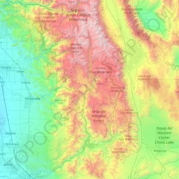
Nom : Carte topographique Sequoia National Forest, altitude, relief.
Altitude moyenne : 1 331 m
Altitude minimum : 68 m
Altitude maximum : 4 288 m