
Carte topographique Anthiyur
Carte interactive
Cliquez sur la carte pour afficher l’altitude.
À propos de cette carte
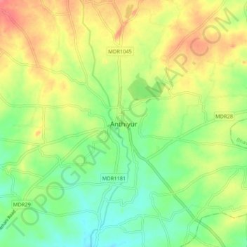
Nom : Carte topographique Anthiyur, altitude, relief.
Lieu : Anthiyur, Erode district, Tamil Nadu, 638502, India (11.53529 77.54860 11.61529 77.62860)
Altitude moyenne : 227 m
Altitude minimum : 199 m
Altitude maximum : 261 m
Anthiyur is located at 11°35′N 77°36′E / 11.58°N 77.60°E / 11.58; 77.60. It has an average elevation of 251 m (823 ft). It is located about 18 km from Bhavani ,30 km from Erode and 93.7 km from Coimbatore.