Géolocaliser

Carte topographique Mont Aiguille

Carte interactive

Cliquez sur la carte pour afficher l’altitude.

À propos de cette carte

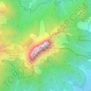
Nom : Carte topographique Mont Aiguille, altitude, relief.

Lieu : Mont Aiguille, Chichilianne, Grenoble, Isère, Auvergne-Rhône-Alpes, France métropolitaine, 38930, France (44.84174 5.55217 44.84184 5.55227)

Altitude moyenne : 1 395 m

Altitude minimum : 1 018 m

Altitude maximum : 2 078 m

Autres cartes topographiques

Cliquez sur une carte pour visualiser sa topographie, son altitude et son relief.

Donnière

France > Auvergne-Rhône-Alpes > Isère > Chichilianne > Donnière

Donnière, Chichilianne, Grenoble, Isère, Auvergne-Rhône-Alpes, France métropolitaine, 38930, France

Altitude moyenne : 1 268 m

Charbonnier

France > Auvergne-Rhône-Alpes > Isère > Chichilianne

Charbonnier, Chichilianne, Grenoble, Isère, Auvergne-Rhône-Alpes, France métropolitaine, 38930, France

Altitude moyenne : 1 125 m

Les Oches

France > Auvergne-Rhône-Alpes > Isère > Chichilianne

Les Oches, Chichilianne, Grenoble, Isère, Auvergne-Rhône-Alpes, France métropolitaine, 38930, France

Altitude moyenne : 1 131 m

Ruthière

France > Auvergne-Rhône-Alpes > Isère > Chichilianne

Ruthière, Chichilianne, Grenoble, Isère, Auvergne-Rhône-Alpes, France métropolitaine, 38930, France

Altitude moyenne : 1 132 m

Richardière

France > Auvergne-Rhône-Alpes > Isère > Chichilianne

Richardière, Chichilianne, Grenoble, Isère, Auvergne-Rhône-Alpes, France métropolitaine, 38930, France

Altitude moyenne : 1 304 m

Prarron

France > Auvergne-Rhône-Alpes > Isère > Chichilianne > Château-Vieux

Prarron, Château-Vieux, Chichilianne, Grenoble, Isère, Auvergne-Rhône-Alpes, France métropolitaine, 38930, France

Altitude moyenne : 1 071 m