
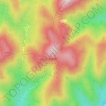
Carte topographique Deraa
Carte interactive
Cliquez sur la carte pour afficher l’altitude.
À propos de cette carte
Nom : Carte topographique Deraa, altitude, relief.
Altitude moyenne : 408 m
Altitude minimum : 101 m
Altitude maximum : 670 m
Autres cartes topographiques
Cliquez sur une carte pour visualiser sa topographie, son altitude et son relief.
Lower Hutt
Nouvelle-Zélande > Wellington > Lower Hutt City
Lower Hutt, Lower Hutt City, Wellington, 5040, Nouvelle-Zélande
Altitude moyenne : 173 m
1390
Nouvelle-Zélande > Wellington > Carterton District
1390, Carterton District, Wellington, Nouvelle-Zélande
Altitude moyenne : 1 062 m
Whakapapa
Nouvelle-Zélande > Wellington > Masterton District
Whakapapa, Masterton District, Wellington, Nouvelle-Zélande
Altitude moyenne : 429 m
Wellington
Nouvelle-Zélande > Wellington > Wellington City
Wellington, Wellington City, Wellington, 6011, Nouvelle-Zélande
Altitude moyenne : 85 m
Lower Hutt City
Nouvelle-Zélande > Wellington > Lower Hutt City
Lower Hutt City, Wellington, Nouvelle-Zélande
Altitude moyenne : 164 m
Lake Wairarapa
Lake Wairarapa, Parera Road, South Wairarapa District, Wellington, Nouvelle-Zélande
Altitude moyenne : 106 m
Greytown
Nouvelle-Zélande > Wellington > Greytown
Greytown, South Wairarapa District, Wellington, 5712, Nouvelle-Zélande
Altitude moyenne : 59 m