
Carte topographique Adjuntas
Carte interactive
Cliquez sur la carte pour afficher l’altitude.
À propos de cette carte
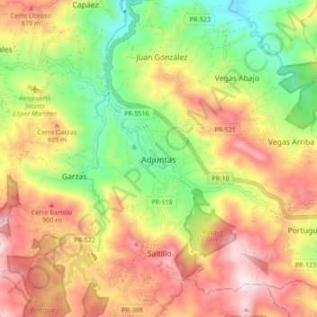
Nom : Carte topographique Adjuntas, altitude, relief.
Lieu : Adjuntas, Puerto Rico, 00601, United States of America (18.12256 -66.76314 18.20256 -66.68314)
Altitude moyenne : 688 m
Altitude minimum : 350 m
Altitude maximum : 1 038 m
Adjuntas features a tropical rainforest climate that borders on a subtropical highland climate. While the town technically features a tropical rainforest climate, due to its high elevation, the climate is noticeably cooler than the norm for this climate category. Summers are warm (83°-85 °F) in the daytime and mild at nighttime (60°-63 °F). Meanwhile, winters are moderately warm with cool temperatures at night. During daytime, high temperatures are around 79 °F (26 °C) in the town and 68 °F (20 °C) in the nearby mountains. Winter night temperatures are between in the 55 °F (13 °C) and 60 °F (16 °C) range, but after cold fronts temperatures can drop down to 45 °F (7 °C).