
Carte topographique Cougar
Carte interactive
Cliquez sur la carte pour afficher l’altitude.
À propos de cette carte
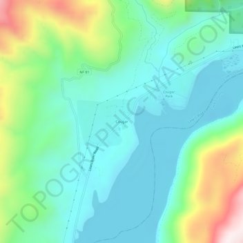
Nom : Carte topographique Cougar, altitude, relief.
Lieu : Cougar, Cowlitz County, Washington, 98616, United States (46.03126 -122.32242 46.07126 -122.28242)
Altitude moyenne : 311 m
Altitude minimum : 131 m
Altitude maximum : 830 m
Autres cartes topographiques
Cliquez sur une carte pour visualiser sa topographie, son altitude et son relief.
Ryderwood
United States > Washington > Cowlitz County
Ryderwood, Cowlitz County, Washington, 98581, United States
Altitude moyenne : 158 m
Toutle River Sediment Retention Structure
United States > Washington > Cowlitz County
Toutle River Sediment Retention Structure, Cowlitz County, Washington, United States
Altitude moyenne : 347 m
Kalama
United States > Washington > Cowlitz County
Kalama, Cowlitz County, Washington, 98625, United States
Altitude moyenne : 58 m
Ariel
United States > Washington > Cowlitz County
Ariel, Cowlitz County, Washington, United States
Altitude moyenne : 206 m
Woodland
United States > Washington > Cowlitz County
Woodland, Cowlitz County, Washington, 98674, United States
Altitude moyenne : 36 m
Yale
United States > Washington > Cowlitz County
Yale, Cowlitz County, Washington, 98603, United States
Altitude moyenne : 257 m
Castle Rock
United States > Washington > Cowlitz County
Castle Rock, Cowlitz County, Washington, 98611, United States
Altitude moyenne : 55 m
Kelso
United States > Washington > Cowlitz County
Kelso, Cowlitz County, Washington, 98626, United States
Altitude moyenne : 52 m