
Carte topographique Seymour
Carte interactive
Cliquez sur la carte pour afficher l’altitude.
À propos de cette carte
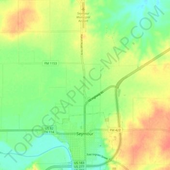
Nom : Carte topographique Seymour, altitude, relief.
Lieu : Seymour, Baylor County, Texas, 76380, United States (33.57758 -99.28730 33.65528 -99.23953)
Altitude moyenne : 401 m
Altitude minimum : 379 m
Altitude maximum : 426 m
The climate is humid subtropical (Köppen: Cfa) with an extreme temperature deviation, but much of the time, the variation is always more and the warm weather prevails over the cold as the averages and the records show. Its subtropical location and south of the center of a large land mass bring occasional outbreaks even to a latitude and not very high altitude. The climate in this area is characterized by hot, humid summers and generally mild to cool winters, sometimes cold. On August 12, 1936, Seymour witnessed the record highest temperature in Texas (120 °F) (49 °C), a record that was tied by the city of Monahans on June 28, 1994.
Autres cartes topographiques
Cliquez sur une carte pour visualiser sa topographie, son altitude et son relief.
Lake Kemp
United States > Texas > Baylor County
Lake Kemp, Baylor County, Texas, United States
Altitude moyenne : 360 m
Red Springs
United States > Texas > Baylor County
Red Springs, Baylor County, Texas, United States
Altitude moyenne : 418 m
Bomarton
United States > Texas > Baylor County
Bomarton, Baylor County, Texas, United States
Altitude moyenne : 429 m
Westover
United States > Texas > Baylor County
Westover, Baylor County, Texas, United States
Altitude moyenne : 393 m
Mabelle
United States > Texas > Baylor County
Mabelle, Baylor County, Texas, United States
Altitude moyenne : 395 m
Seymour
United States > Texas > Baylor County
Seymour, Baylor County, Texas, 76380, United States
Altitude moyenne : 401 m