
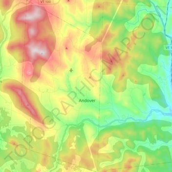
Carte topographique Andover
Carte interactive
Cliquez sur la carte pour afficher l’altitude.
À propos de cette carte
Nom : Carte topographique Andover, altitude, relief.
Lieu : Andover, Windsor County, Vermont, United States (43.22258 -72.76520 43.35377 -72.68144)
Altitude moyenne : 468 m
Altitude minimum : 189 m
Altitude maximum : 865 m
Autres cartes topographiques
Cliquez sur une carte pour visualiser sa topographie, son altitude et son relief.
White River
United States > Vermont > Windsor County
White River, Windsor County, Vermont, United States
Altitude moyenne : 419 m
The Alps
United States > Vermont > Windsor County > Reading
The Alps, Reading, Windsor County, Vermont, United States
Altitude moyenne : 551 m
South Royalton
United States > Vermont > Windsor County
South Royalton, Royalton, Windsor County, Vermont, 05068, United States
Altitude moyenne : 239 m
Old Baldy Mountain
United States > Vermont > Windsor County > Woodstock
Old Baldy Mountain, Woodstock, Windsor County, Vermont, 05034, United States
Altitude moyenne : 527 m
Royalton
United States > Vermont > Windsor County
Royalton, Windsor County, Vermont, 05068, United States
Altitude moyenne : 312 m
Norwich
United States > Vermont > Windsor County
Norwich, Windsor County, Vermont, 05055, United States
Altitude moyenne : 289 m
Barnard
United States > Vermont > Windsor County
Barnard, Windsor County, Vermont, United States
Altitude moyenne : 463 m
Windsor
United States > Vermont > Windsor County
Windsor, Windsor County, Vermont, 05089, United States
Altitude moyenne : 257 m
Chester
United States > Vermont > Windsor County
Chester, Windsor County, Vermont, 05143, United States
Altitude moyenne : 317 m
West Windsor
United States > Vermont > Windsor County
West Windsor, Windsor County, Vermont, 05037, United States
Altitude moyenne : 366 m
Springfield
United States > Vermont > Windsor County
Springfield, Windsor County, Vermont, United States
Altitude moyenne : 238 m
Ascutney
United States > Vermont > Windsor County > Weathersfield > Ascutney
Ascutney, Weathersfield, Windsor County, Vermont, 05030, United States
Altitude moyenne : 167 m
White River Junction
United States > Vermont > Windsor County > Hartford
White River Junction, Hartford, Windsor County, Vermont, 03784, United States
Altitude moyenne : 160 m
Chester
United States > Vermont > Windsor County > Chester > Chester
Chester, Windsor County, Vermont, 05143, United States
Altitude moyenne : 237 m
Rochester
United States > Vermont > Windsor County > Rochester
Rochester, Windsor County, Vermont, 05767, United States
Altitude moyenne : 516 m
Hartland
United States > Vermont > Windsor County
Hartland, Windsor County, Vermont, United States
Altitude moyenne : 261 m
Quechee
United States > Vermont > Windsor County > Hartford
Quechee, Hartford, Windsor County, Vermont, 05059, United States
Altitude moyenne : 231 m
Ludlow
United States > Vermont > Windsor County
Ludlow, Windsor County, Vermont, United States
Altitude moyenne : 496 m