
Carte topographique Bhojpur
Carte interactive
Cliquez sur la carte pour afficher l’altitude.
À propos de cette carte
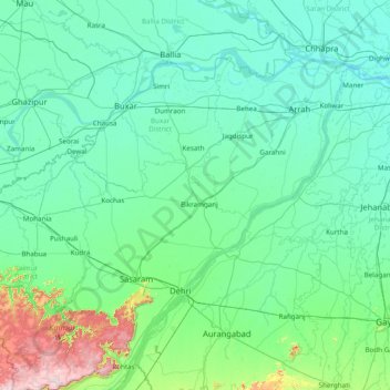
Nom : Carte topographique Bhojpur, altitude, relief.
Lieu : Bhojpur, Rohtas, Bihar, 802212, Inde (24.61000 83.61000 25.89000 84.89000)
Altitude moyenne : 99 m
Altitude minimum : 44 m
Altitude maximum : 599 m
Autres cartes topographiques
Cliquez sur une carte pour visualiser sa topographie, son altitude et son relief.
Sahebpur Kamal
Inde > Bihar > Sahebpur Kamal
Sahebpur Kamal, Begusarai, Bihar, 851217, Inde
Altitude moyenne : 40 m
Patna
Inde > Bihar > Patna Rural
Patna, Patna Rural, Patna District, Bihar, 800001, Inde
Altitude moyenne : 51 m
Gaya
Inde > Bihar > Gaya Town C.D.Block
Gaya, Gaya Town C.D.Block, Gaya District, Bihar, 823001, Inde
Altitude moyenne : 111 m
Bagmati River
Bagmati River, Sītāmarhi, Sitamarhi, Bihar, 843321, Inde
Altitude moyenne : 422 m