
Carte topographique Thiruvananthapuram
Carte interactive
Cliquez sur la carte pour afficher l’altitude.
À propos de cette carte
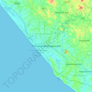
Nom : Carte topographique Thiruvananthapuram, altitude, relief.
Altitude moyenne : 33 m
Altitude minimum : -1 m
Altitude maximum : 316 m
Thiruvananthapuram is built on seven hills by the seashore and is at 8°30′N 76°54′E / 8.5°N 76.9°E / 8.5; 76.9 on the west coast, near the southern tip of mainland India. The city is on the west coast of India and is bounded by the Laccadive Sea to its west and the Western Ghats to its east. The average elevation of the city is 16 ft (4.9 m) above sea level. The Geological Survey of India has identified Thiruvananthapuram as a moderately earthquake-prone urban centre and categorised the metropolis in the Seismic III Zone. Thiruvananthapuram lies on the shores of Karamana and Killi rivers. Vellayani, Thiruvallam and Aakulam backwaters lie in the city. The soil type in the middle part of the city is a dark brown loamy laterite soil high in phosphates. Laterisation is a result of the heavy rainfall and humid conditions. In western coastal regions of the city, sandy loam soil is found, and on hilly eastern parts of the district, rich dark brown loam of granite origin is found.
Autres cartes topographiques
Cliquez sur une carte pour visualiser sa topographie, son altitude et son relief.
Andoorkonam
India > Kerala > Thiruvananthapuram > Varikkamukku
Andoorkonam, Varikkamukku, Thiruvananthapuram, Thiruvananthapuram District, Kerala, India
Altitude moyenne : 24 m
Kariyam
India > Kerala > Thiruvananthapuram
Kariyam, Thiruvananthapuram, Thiruvananthapuram District, Kerala, 695588, India
Altitude moyenne : 40 m
Powdiconam or Society Mukku
India > Kerala > Thiruvananthapuram
Powdiconam or Society Mukku, Thiruvananthapuram, Thiruvananthapuram District, Kerala, India
Altitude moyenne : 46 m
Kalliyoor
India > Kerala > Thiruvananthapuram > Thiruvananthapuram
Kalliyoor, Thiruvananthapuram, Thiruvananthapuram District, Kerala, 695001, India
Altitude moyenne : 30 m
Chavadimukku
India > Kerala > Thiruvananthapuram > Thiruvananthapuram
Chavadimukku, Sreekariyam, Thiruvananthapuram, Kerala, 695001, India
Altitude moyenne : 39 m
Thumba
India > Kerala > Thiruvananthapuram
Thumba, Thiruvananthapuram, Kerala, 695016, India
Altitude moyenne : 9 m
Mangalapuram
India > Kerala > Thiruvananthapuram
Mangalapuram, Thiruvananthapuram, Kerala, 695317, India
Altitude moyenne : 33 m
Aakkulam Lake
India > Kerala > Thiruvananthapuram > Thiruvananthapuram
Aakkulam Lake, Akkulam, Thiruvananthapuram, Thiruvananthapuram District, Kerala, 695001, India
Altitude moyenne : 12 m
Kakkamoola
India > Kerala > Thiruvananthapuram
Kakkamoola, Thiruvananthapuram, Kerala, 695042, India
Altitude moyenne : 34 m
Kanakakkunnu Palace
India > Kerala > Thiruvananthapuram > Thiruvananthapuram
Kanakakkunnu Palace, Museum Road, Vellayambalam, Thiruvananthapuram, Kerala, 695001, India
Altitude moyenne : 35 m
Kadinamkulam
India > Kerala > Thiruvananthapuram > Puthenthope
Kadinamkulam, Puthenthope, Thiruvananthapuram, Thiruvananthapuram District, Kerala, India
Altitude moyenne : 10 m
Kovalam
India > Kerala > Thiruvananthapuram
Kovalam, Thiruvananthapuram, Kerala, 695527, India
Altitude moyenne : 24 m
Kaniyapuram
India > Kerala > Thiruvananthapuram
Kaniyapuram, Thiruvananthapuram, Kerala, 695301, India
Altitude moyenne : 15 m