
Carte topographique Ashburton
Carte interactive
Cliquez sur la carte pour afficher l’altitude.
À propos de cette carte
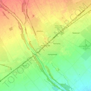
Nom : Carte topographique Ashburton, altitude, relief.
Altitude moyenne : 99 m
Altitude minimum : 67 m
Altitude maximum : 132 m
On the whole, Ashburton shares a similar climate to Christchurch i.e. a dry temperate climate (Cfb). However, since it lies further inland at a higher altitude to Christchurch, Ashburton experiences a greater range of temperatures. During summer Ashburton can exceed 30 °C (86 °F), whilst winter can see regular frosts and annual snowfall. Ashburton's heaviest snowfall was 38 centimetres (15 in) on 12 June 2006, conversely it is tied with Timaru for New Zealand's fourth-highest temperature on record, reaching 41.3 °C (106.3 °F) on 7 February 1973.
Autres cartes topographiques
Cliquez sur une carte pour visualiser sa topographie, son altitude et son relief.
Ōtūroto / Lake Heron
New Zealand > Canterbury > Ashburton District
Ōtūroto / Lake Heron, Ashburton District, Canterbury, New Zealand
Altitude moyenne : 750 m
Totara Peak
New Zealand > Canterbury > Ashburton District
Totara Peak, Ashburton District, Canterbury, New Zealand
Altitude moyenne : 1 645 m
Rakaia Gorge lookout
New Zealand > Canterbury > Ashburton District
Rakaia Gorge lookout, Arundel Rakaia Gorge Road, Ashburton District, Canterbury, New Zealand
Altitude moyenne : 358 m
Dromore
New Zealand > Canterbury > Ashburton District
Dromore, Ashburton District, Canterbury, 7772, New Zealand
Altitude moyenne : 123 m
Methven
New Zealand > Canterbury > Ashburton District
Methven, Ashburton District, Canterbury, 7730, New Zealand
Altitude moyenne : 322 m
Hackthorne
New Zealand > Canterbury > Ashburton District
Hackthorne, Ashburton District, Canterbury, New Zealand
Altitude moyenne : 199 m
Mayfield
New Zealand > Canterbury > Ashburton District
Mayfield, Ashburton District, Canterbury, 7778, New Zealand
Altitude moyenne : 266 m
Ashburton Lakes
New Zealand > Canterbury > Ashburton District
Ashburton Lakes, Ashburton District, Canterbury, New Zealand
Altitude moyenne : 645 m
Ruapuna
New Zealand > Canterbury > Ashburton District
Ruapuna, Ashburton District, Canterbury, New Zealand
Altitude moyenne : 302 m
Mount Somers
New Zealand > Canterbury > Ashburton District
Mount Somers, Ashburton District, Canterbury, New Zealand
Altitude moyenne : 1 221 m
Lake Clearwater
New Zealand > Canterbury > Ashburton District
Lake Clearwater, Ashburton District, Canterbury, New Zealand
Altitude moyenne : 751 m