
Carte topographique Kootstertille
Carte interactive
Cliquez sur la carte pour afficher l’altitude.
À propos de cette carte
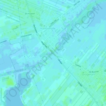
Nom : Carte topographique Kootstertille, altitude, relief.
Altitude moyenne : 2 m
Altitude minimum : -4 m
Altitude maximum : 7 m
Autres cartes topographiques
Cliquez sur une carte pour visualiser sa topographie, son altitude et son relief.
Buitenpost
Nederland > Friesland > Achtkarspelen > Buitenpost
Buitenpost, Achtkarspelen, Friesland, Nederland, 9285, Nederland
Altitude moyenne : 1 m