
Carte topographique Rishikesh
Carte interactive
Cliquez sur la carte pour afficher l’altitude.
À propos de cette carte
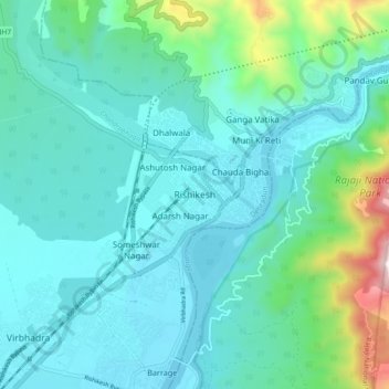
Nom : Carte topographique Rishikesh, altitude, relief.
Lieu : Rishikesh, Dehradun, Uttarakhand, 249201, India (30.06865 78.25162 30.14865 78.33162)
Altitude moyenne : 497 m
Altitude minimum : 323 m
Altitude maximum : 1 363 m
Rishikesh is at 30°06′12″N 78°17′41″E / 30.103368°N 78.294754°E / 30.103368; 78.294754. It has an average elevation of 372 metres (1,220 ft). The town is located in the Tehri Garhwal region of the northern Indian state of Uttarakhand.
Autres cartes topographiques
Cliquez sur une carte pour visualiser sa topographie, son altitude et son relief.
Virbhadra
India > Uttarakhand > Rishikesh
Virbhadra, Rishikesh, Dehradun, Uttarakhand, 249201, India
Altitude moyenne : 356 m