
Carte topographique Srirangapatna
Carte interactive
Cliquez sur la carte pour afficher l’altitude.
À propos de cette carte
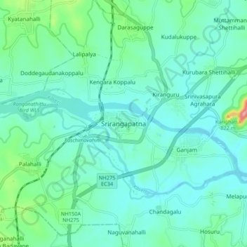
Nom : Carte topographique Srirangapatna, altitude, relief.
Altitude moyenne : 693 m
Altitude minimum : 665 m
Altitude maximum : 824 m
Srirangapatna is at 12°25′N 76°42′E / 12.41°N 76.7°E / 12.41; 76.7. It has an average elevation of 679 metres (2227 feet). Srirangapatna Sangama is the confluence of the three holy streams creating the island. Located 27 km upstream from the town is the spectacular Shivanasamudra Falls, the second biggest waterfall in India and the 16th largest in the world.
Autres cartes topographiques
Cliquez sur une carte pour visualiser sa topographie, son altitude et son relief.
Ganjam
India > Karnataka > Srirangapattana taluk > Ganjam
Ganjam, Srirangapattana taluk, Mandya district, Karnataka, 570020, India
Altitude moyenne : 684 m