
Carte topographique Meghalaya
Carte interactive
Cliquez sur la carte pour afficher l’altitude.
À propos de cette carte
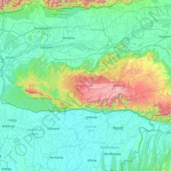
Nom : Carte topographique Meghalaya, altitude, relief.
Lieu : Meghalaya, Inde (25.03065 89.81444 26.11817 92.80274)
Altitude moyenne : 244 m
Altitude minimum : 0 m
Altitude maximum : 2 336 m
Le climat du Meghalaya est modéré mais humide, la moyenne annuelle des précipitations atteignant 12 000 mm (12 mètres) dans certaines zones, ce qui en fait l'État le plus arrosé de la fédération. La ville de Cherrapunji, au sud de la capitale, détient le record mondial des précipitations sur un mois, tandis que le village de Mawsynram, près de Cherrapunji, détient celui du record des précipitations sur une année. Un tiers du Meghalaya est couvert de forêts. La chaîne des Garo à l'Ouest, celle des Khasi et celle des Jaintia à l'Est, sont d'une altitude modérée, le point culminant étant le pic Shillong s'élevant à 1 965 m.
Autres cartes topographiques
Cliquez sur une carte pour visualiser sa topographie, son altitude et son relief.
Chage
Inde > Karnataka > Sidlaghatta taluk > Kempanahalli
Chage, Kempanahalli, Sidlaghatta taluk, Chikkaballapura District, Karnataka, 562105, Inde
Altitude moyenne : 902 m
Sain
Inde > Madhya Pradesh > Sardarpur Tahsil > Akolya
Sain, Akolya, Sardarpur Tahsil, Dhar District, Madhya Pradesh, Inde
Altitude moyenne : 484 m
Chaumo
Inde > Madhya Pradesh > Dabra Tahsil > Chomo
Chaumo, Chomo, Dabra Tahsil, Gwalior District, Madhya Pradesh, Inde
Altitude moyenne : 233 m
Greater Hyderabad Municipal Corporation Central Zone
Inde > Telangana > Khairatabad mandal > Hyderabad
Greater Hyderabad Municipal Corporation Central Zone, Hyderabad, Khairatabad mandal, Hyderabad District, Telangana, Inde
Altitude moyenne : 533 m
Bhopal
Inde > Madhya Pradesh > Huzur Tahsil
Bhopal, Huzur Tahsil, Bhopal District, Madhya Pradesh, 462001, Inde
Altitude moyenne : 498 m
Andey
Inde > Telangana > Mirdoddi mandal
Andey, Mirdoddi mandal, Siddipet District, Telangana, Inde
Altitude moyenne : 504 m
Ramnagar
Ramnagar, Udhampur District, Jammu-et-Cachemire, Inde
Altitude moyenne : 1 790 m
Namche
Inde > Ladakh > Kargil tehsil
Namche, Kargil tehsil, Kargil District, Ladakh, Inde
Altitude moyenne : 3 861 m
Saket
Inde > Delhi > Hauz Khas Tehsil
Saket, Hauz Khas Tehsil, South Delhi District, Delhi, Inde
Altitude moyenne : 231 m
Mahrajganj
Inde > Uttar Pradesh > Sagri
Mahrajganj, Sagri, Azamgarh District, Uttar Pradesh, 276139, Inde
Altitude moyenne : 79 m
Hemis
Inde > Ladakh > Leh tehsil
Hemis, Leh Tehsil, Leh District, Ladakh, Inde
Altitude moyenne : 5 218 m
Zanskar
Inde > Ladakh > Zanskar tehsil
Zanskar, Zanskar tehsil, Kargil District, Ladakh, Inde
Altitude moyenne : 4 285 m
Phyang
Inde > Ladakh > Leh tehsil
Phyang, Leh Tehsil, Leh District, Ladakh, 194101, Inde
Altitude moyenne : 3 742 m
Leta
Inde > Rajasthan > Jalor Tehsil
Leta, Jalor Tehsil, Jalore District, Rajasthan, Inde
Altitude moyenne : 173 m
Salse
Inde > Maharashtra > Karmala
Salse, Karmala, Solapur, Maharashtra, 413313, Inde
Altitude moyenne : 533 m
Tingi
Inde > Madhya Pradesh > Kusmi Tahsil
Tingi, Kusmi Tahsil, Sidhi District, Madhya Pradesh, Inde
Altitude moyenne : 536 m
Habra
Inde > Bengale-Occidental > Habra - I
Habra, Habra - I, North 24 Parganas District, Bengale-Occidental, 743263, Inde
Altitude moyenne : 7 m
Mehdi
Inde > Madhya Pradesh > Majhgawan Tahsil > Tamar
Mehdi, Tamar, Majhgawan Tahsil, Satna District, Madhya Pradesh, Inde
Altitude moyenne : 377 m
Hyderabad
Inde > Telangana > Bahadurpura mandal
Hyderabad, Bahadurpura mandal, Hyderabad District, Telangana, Inde
Altitude moyenne : 549 m
Haidra
Inde > Maharashtra > Akkalkot
Haidra, Akkalkot, Solapur, Maharashtra, 585217, Inde
Altitude moyenne : 448 m
Kalpa
Kalpa, Kinnaur District, Himachal Pradesh, Inde
Altitude moyenne : 3 777 m
Chitkul
Inde > Telangana > Chilipched mandal
Chitkul, Chilipched mandal, Medak District, Telangana, Inde
Altitude moyenne : 493 m
Kamru
Inde > Himachal Pradesh > Sangla
Kamru, Sangla, Kinnaur District, Himachal Pradesh, 172106, Inde
Altitude moyenne : 3 009 m
Marol
Inde > Madhya Pradesh > Sardarpur Tahsil
Marol, Sardarpur Tahsil, Dhar District, Madhya Pradesh, Inde
Altitude moyenne : 556 m
Chhota
Inde > Madhya Pradesh > Gotegaon Tahsil
Chhota, Gotegaon Tahsil, Narsinghpur District, Madhya Pradesh, Inde
Altitude moyenne : 432 m
Shey
Inde > Ladakh > Leh tehsil
Shey, Leh Tehsil, Leh District, Ladakh, Inde
Altitude moyenne : 3 282 m
Khach
Inde > Madhya Pradesh > Birsinghpur Tahsil > Khanch
Khach, Khanch, Birsinghpur Tahsil, Satna District, Madhya Pradesh, Inde
Altitude moyenne : 322 m
Dunai
Inde > Madhya Pradesh > Guna Tahsil
Dunai, Guna Tahsil, Guna District, Madhya Pradesh, Inde
Altitude moyenne : 492 m
Ward 127 Rangareddy Nagar
Inde > Telangana > Kukatpally mandal > Hyderabad
Ward 127 Rangareddy Nagar, Greater Hyderabad Municipal Corporation North Zone, Hyderabad, Kukatpally mandal, Medchal–Malkajgiri District, Telangana, Inde
Altitude moyenne : 557 m
Padron
Inde > Himachal Pradesh > Chamba
Padron, Chamba, Chamba District, Himachal Pradesh, Inde
Altitude moyenne : 1 817 m
Thattekad
Inde > Kerala > Kothamangalam
Thattekad, Kothamangalam, Ernakulam District, Kerala, 686681, Inde
Altitude moyenne : 101 m
Solakarai
Inde > Tamil Nadu > Coimbatore South
Solakarai, Coimbatore South, Coimbatore District, Tamil Nadu, 678624, Inde
Altitude moyenne : 224 m
Autan
Inde > Himachal Pradesh > Banjar
Autan, Banjar, Kullu District, Himachal Pradesh, Inde
Altitude moyenne : 1 797 m
Bagni
Inde > Madhya Pradesh > Jharda Tahsil > Bhatkhedi
Bagni, Bhatkhedi, Jharda Tahsil, Ujjain District, Madhya Pradesh, Inde
Altitude moyenne : 472 m
Mongra
Inde > Madhya Pradesh > Pipariya Tahsil
Mongra, Pipariya Tahsil, Narmadapuram District, Madhya Pradesh, Inde
Altitude moyenne : 403 m
Karia
Inde > Madhya Pradesh > Chachaura Tahsil > Kadaiya Chachaura
Karia, Kadaiya Chachaura, Chachaura Tahsil, Guna District, Madhya Pradesh, Inde
Altitude moyenne : 414 m
Narayani
Inde > Madhya Pradesh > Garoth Tahsil
Narayani, Garoth Tahsil, Mandsaur District, Madhya Pradesh, Inde
Altitude moyenne : 421 m
Mangat
Inde > Pendjab > Ludhiana (East) Tahsil
Mangat, Ludhiana (East) Tahsil, Ludhiana District, Pendjab, Inde
Altitude moyenne : 243 m
Dobhan
Inde > Madhya Pradesh > Nasrullaganj Tahsil
Dobhan, Nasrullaganj Tahsil, Sehore District, Madhya Pradesh, Inde
Altitude moyenne : 303 m
Mayur Vihar Tehsil
Mayur Vihar Tehsil, East Delhi District, Delhi, Inde
Altitude moyenne : 204 m
Naka
Inde > Madhya Pradesh > Bamor Tahsil
Naka, Bamor Tahsil, Morena District, Madhya Pradesh, Inde
Altitude moyenne : 164 m