
Carte topographique Khôst
Carte interactive
Cliquez sur la carte pour afficher l’altitude.
À propos de cette carte
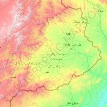
Nom : Carte topographique Khôst, altitude, relief.
Lieu : Khôst, Afghanistan (33.01939 69.34557 33.73867 70.32851)
Altitude moyenne : 1 699 m
Altitude minimum : 551 m
Altitude maximum : 3 641 m
Autres cartes topographiques
Cliquez sur une carte pour visualiser sa topographie, son altitude et son relief.
villege
Afghanistan > Khôst > نادرشاه کوټ ولسوالۍ > villege
villege, نادرشاه کوټ ولسوالۍ, Khôst, Afghanistan
Altitude moyenne : 1 484 m