
Carte topographique Whakamarama
Carte interactive
Cliquez sur la carte pour afficher l’altitude.
À propos de cette carte
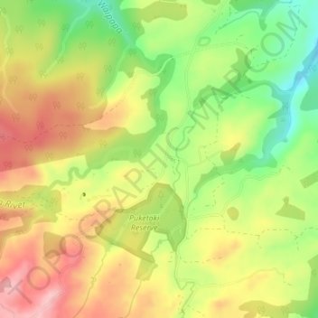
Nom : Carte topographique Whakamarama, altitude, relief.
Altitude moyenne : 266 m
Altitude minimum : 180 m
Altitude maximum : 345 m
Autres cartes topographiques
Cliquez sur une carte pour visualiser sa topographie, son altitude et son relief.
Tauranga City
Nouvelle-Zélande > Bay of Plenty
Tauranga City, Bay of Plenty, Nouvelle-Zélande
Altitude moyenne : 55 m
Rotorua Lakes District
Nouvelle-Zélande > Bay of Plenty
Rotorua Lakes District, Bay of Plenty, Nouvelle-Zélande
Altitude moyenne : 404 m
Wairere Falls
Nouvelle-Zélande > Bay of Plenty > Rotorua
Wairere Falls, Rotorua, Rotorua District, Bay of Plenty, Nouvelle-Zélande
Altitude moyenne : 451 m
Mayor Island / Tuhua
Nouvelle-Zélande > Bay of Plenty > Tauranga
Mayor Island / Tuhua, Tauranga, Bay of Plenty, Nouvelle-Zélande
Altitude moyenne : 71 m
Lake Ōkataina
Nouvelle-Zélande > Bay of Plenty > Ruato
Lake Ōkataina, Eastern Okataina Walkway, Ruato, Rotorua District, Bay of Plenty, Nouvelle-Zélande
Altitude moyenne : 440 m
Whakatāne District
Nouvelle-Zélande > Bay of Plenty
Whakatāne District, Bay of Plenty, Nouvelle-Zélande
Altitude moyenne : 416 m
Rotorua
Nouvelle-Zélande > Bay of Plenty > Rotorua Lakes District
Rotorua, Rotorua Lakes District, Bay of Plenty, 3010, Nouvelle-Zélande
Altitude moyenne : 435 m