
Carte topographique Sedro-Woolley
Carte interactive
Cliquez sur la carte pour afficher l’altitude.
À propos de cette carte
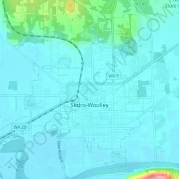
Nom : Carte topographique Sedro-Woolley, altitude, relief.
Lieu : Sedro-Woolley, Skagit County, Washington, United States (48.48828 -122.28041 48.52960 -122.20984)
Altitude moyenne : 28 m
Altitude minimum : 8 m
Altitude maximum : 220 m
Autres cartes topographiques
Cliquez sur une carte pour visualiser sa topographie, son altitude et son relief.
Mount Erie
United States > Washington > Skagit County > Anacortes
Mount Erie, Anacortes, Skagit County, Washington, 98221, United States
Altitude moyenne : 128 m
Marblemount
United States > Washington > Skagit County
Marblemount, Skagit County, Washington, United States
Altitude moyenne : 249 m
Big Lake
United States > Washington > Skagit County
Big Lake, Skagit County, Washington, 98274, United States
Altitude moyenne : 80 m
Anacortes
United States > Washington > Skagit County
Anacortes, Skagit County, Washington, 98221, United States
Altitude moyenne : 36 m
Anacortes
United States > Washington > Skagit County > Anacortes > Anacortes
Anacortes, Skagit County, Washington, 98221, United States
Altitude moyenne : 37 m
Concrete
United States > Washington > Skagit County
Concrete, Skagit County, Washington, United States
Altitude moyenne : 125 m
Coal Mountain
United States > Washington > Skagit County
Coal Mountain, Skagit County, Washington, United States
Altitude moyenne : 1 003 m
Burlington
United States > Washington > Skagit County
Burlington, Skagit County, Washington, 98233, United States
Altitude moyenne : 12 m
Mount Vernon
United States > Washington > Skagit County
Mount Vernon, Skagit County, Washington, 98273, United States
Altitude moyenne : 37 m