
Carte topographique Baggeridge Country Park
Carte interactive
Cliquez sur la carte pour afficher l’altitude.
À propos de cette carte
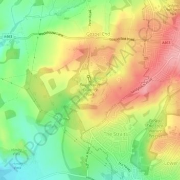
Nom : Carte topographique Baggeridge Country Park, altitude, relief.
Altitude moyenne : 146 m
Altitude minimum : 86 m
Altitude maximum : 206 m
Autres cartes topographiques
Cliquez sur une carte pour visualiser sa topographie, son altitude et son relief.
Kinver Edge
United Kingdom > England > South Staffordshire
Kinver Edge, South Staffordshire, Staffordshire, West Midlands, England, DY7 5NP, United Kingdom
Altitude moyenne : 93 m
Kinver
United Kingdom > England > South Staffordshire > Kinver
Kinver, South Staffordshire, Staffordshire, West Midlands, England, DY7 6HF, United Kingdom
Altitude moyenne : 81 m
Penkridge
United Kingdom > England > South Staffordshire > Penkridge
Penkridge, South Staffordshire, Staffordshire, West Midlands, England, ST19 5DJ, United Kingdom
Altitude moyenne : 104 m
Trysull and Seisdon
United Kingdom > England > South Staffordshire
Trysull and Seisdon, South Staffordshire, Staffordshire, West Midlands, England, United Kingdom
Altitude moyenne : 95 m
Middle Pool
United Kingdom > England > South Staffordshire
Middle Pool, Crateford Lane, Brewood and Coven, South Staffordshire, Staffordshire, West Midlands, England, ST19 5PZ, United Kingdom
Altitude moyenne : 100 m
Shareshill
United Kingdom > England > South Staffordshire
Shareshill, South Staffordshire, Staffordshire, West Midlands, England, United Kingdom
Altitude moyenne : 123 m
Lapley, Stretton and Wheaton Aston
United Kingdom > England > South Staffordshire
Lapley, Stretton and Wheaton Aston, South Staffordshire, Staffordshire, West Midlands, England, United Kingdom
Altitude moyenne : 107 m