
Carte topographique Queenstown-Lakes District
Carte interactive
Cliquez sur la carte pour afficher l’altitude.
À propos de cette carte
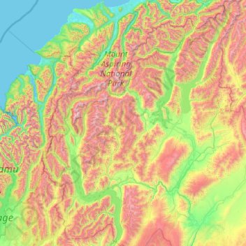
Nom : Carte topographique Queenstown-Lakes District, altitude, relief.
Lieu : Queenstown-Lakes District, Otago, Nouvelle-Zélande (-45.36757 168.11639 -43.95541 169.71978)
Altitude moyenne : 832 m
Altitude minimum : -1 m
Altitude maximum : 2 819 m
Autres cartes topographiques
Cliquez sur une carte pour visualiser sa topographie, son altitude et son relief.
Mount Pisa
Nouvelle-Zélande > Otago > Queenstown-Lakes District
Mount Pisa, Queenstown-Lakes District, Otago, Nouvelle-Zélande
Altitude moyenne : 1 739 m
Tiger Hill
Nouvelle-Zélande > Otago > Central Otago District > Vincent Community
Tiger Hill, Vincent Community, Central Otago District, Otago, 9376, Nouvelle-Zélande
Altitude moyenne : 393 m
Lac Wanaka
Nouvelle-Zélande > Otago > Queenstown-Lakes District
Lac Wanaka, Queenstown-Lakes District, Otago, Nouvelle-Zélande
Altitude moyenne : 812 m
Queenstown
Nouvelle-Zélande > Otago > Queenstown-Lakes District
Queenstown, Queenstown-Lakes District, Otago, 9348, Nouvelle-Zélande
Altitude moyenne : 592 m
Crossans Corner
Nouvelle-Zélande > Otago > Clutha District
Crossans Corner, Clutha District, Otago, Nouvelle-Zélande
Altitude moyenne : 164 m
Dunedin
Nouvelle-Zélande > Otago > Dunedin City
Dunedin, Dunedin City, Otago, 9016, Nouvelle-Zélande
Altitude moyenne : 110 m
Arrowtown
Nouvelle-Zélande > Otago > Queenstown-Lakes District
Arrowtown, Queenstown-Lakes District, Otago, 9302, Nouvelle-Zélande
Altitude moyenne : 671 m