
Carte topographique Riggins
Carte interactive
Cliquez sur la carte pour afficher l’altitude.
À propos de cette carte
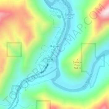
Nom : Carte topographique Riggins, altitude, relief.
Lieu : Riggins, Idaho County, Idaho, 83549, United States (45.40719 -116.33166 45.43308 -116.31000)
Altitude moyenne : 706 m
Altitude minimum : 509 m
Altitude maximum : 1 144 m
Riggins is a city in the western United States in Idaho County, Idaho. Nestled deep in a canyon at the confluence of the Salmon and Little Salmon rivers in west central Idaho, it is approximately 150 highway miles (240 km) north of Boise, and 120 highway miles (190 km) south-southeast of Lewiston. The elevation is 1,821 feet (555 m) above sea level, and its population was 419 at the 2010 census.
Autres cartes topographiques
Cliquez sur une carte pour visualiser sa topographie, son altitude et son relief.
Nugget Point
United States > Idaho > Idaho County
Nugget Point, Idaho County, Idaho, United States
Altitude moyenne : 1 659 m
Grangeville
United States > Idaho > Idaho County
Grangeville, Idaho County, Idaho, United States
Altitude moyenne : 1 037 m
The Maze
United States > Idaho > Idaho County
The Maze, Idaho County, Idaho, United States
Altitude moyenne : 533 m
Dry Can Creek
United States > Idaho > Idaho County
Dry Can Creek, Idaho County, Idaho, United States
Altitude moyenne : 1 163 m