
Carte topographique La Fonderie
Carte interactive
Cliquez sur la carte pour afficher l’altitude.
À propos de cette carte
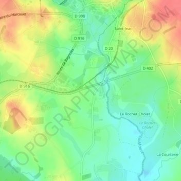
Nom : Carte topographique La Fonderie, altitude, relief.
Altitude moyenne : 195 m
Altitude minimum : 169 m
Altitude maximum : 228 m
Autres cartes topographiques
Cliquez sur une carte pour visualiser sa topographie, son altitude et son relief.
La Haute Allée
France > Normandie > La Ferté-Macé
La Haute Allée, La Ferté-Macé, Argentan, Orne, Normandie, France métropolitaine, 61600, France
Altitude moyenne : 262 m