
Carte topographique Perth
Carte interactive
Cliquez sur la carte pour afficher l’altitude.
À propos de cette carte
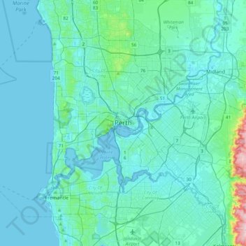
Nom : Carte topographique Perth, altitude, relief.
Lieu : Perth, City of Perth, Western Australia, 6000, Australia (-32.11589 115.70059 -31.79589 116.02059)
Altitude moyenne : 26 m
Altitude minimum : -2 m
Altitude maximum : 288 m
Autres cartes topographiques
Cliquez sur une carte pour visualiser sa topographie, son altitude et son relief.
Swan River
Australia > Western Australia > City of Perth
Swan River, City of Perth, Western Australia, Australia
Altitude moyenne : 57 m
Kings Park
Australia > Western Australia > City of Perth > Perth
Kings Park, Crawley, Kings Park, Perth, City of Perth, Western Australia, Australia
Altitude moyenne : 31 m
Langley Park
Australia > Western Australia > City of Perth > Perth
Langley Park, East Perth, Perth, City of Perth, Western Australia, Australia
Altitude moyenne : 9 m
East Perth
Australia > Western Australia > City of Perth
East Perth, City of Perth, Western Australia, 6004, Australia
Altitude moyenne : 9 m
Crawley
Australia > Western Australia > City of Perth > Perth
Crawley, Perth, City of Perth, Western Australia, 6009, Australia
Altitude moyenne : 13 m
West Perth
Australia > Western Australia > City of Perth
West Perth, City of Perth, Western Australia, 6005, Australia
Altitude moyenne : 26 m
Northbridge
Australia > Western Australia > City of Perth > Perth
Northbridge, Perth, City of Perth, Western Australia, 6003, Australia
Altitude moyenne : 24 m
Russell Square
Australia > Western Australia > City of Perth > Perth
Russell Square, Northbridge, Perth, City of Perth, Western Australia, Australia
Altitude moyenne : 25 m
Acacia Garden
Australia > Western Australia > City of Perth > Perth
Acacia Garden, Kings Park, Perth, City of Perth, Western Australia, 6005, Australia
Altitude moyenne : 27 m