
Carte topographique Waynesville
Carte interactive
Cliquez sur la carte pour afficher l’altitude.
À propos de cette carte
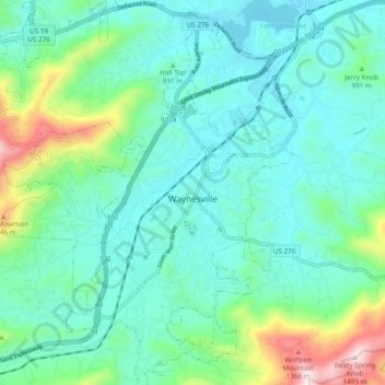
Nom : Carte topographique Waynesville, altitude, relief.
Altitude moyenne : 921 m
Altitude minimum : 772 m
Altitude maximum : 1 484 m
Most of the town of Waynesville lies between 2,600 and 3,000 feet (790 and 910 m) above sea level, in a valley among 5,000-to-6,410-foot (1,520 to 1,950 m) mountain peaks. With the high Great Balsam Mountains to the west-southwest, and the Plott Balsams to the west-northwest, a handful of peaks over 6000' in elevation are clearly visible from town. A USGS survey marker at the old Haywood County Courthouse in downtown Waynesville lists the elevation as 2,752 feet (839 m) above sea level.
Autres cartes topographiques
Cliquez sur une carte pour visualiser sa topographie, son altitude et son relief.
Mount Lyn Lowry
United States > North Carolina > Haywood County
Mount Lyn Lowry, Haywood County, North Carolina, United States
Altitude moyenne : 1 586 m
Little Bird Falls
United States > North Carolina > Haywood County
Little Bird Falls, Haywood County, North Carolina, United States
Altitude moyenne : 1 347 m
Lake Junaluska
United States > North Carolina > Haywood County
Lake Junaluska, Haywood County, North Carolina, 28745, United States
Altitude moyenne : 862 m
Lake Logan
United States > North Carolina > Haywood County > Sunburst
Lake Logan, Sunburst, Haywood County, North Carolina, United States
Altitude moyenne : 1 061 m
Sugartree Licks
United States > North Carolina > Haywood County
Sugartree Licks, Haywood County, North Carolina, United States
Altitude moyenne : 1 505 m
Hazelwood
United States > North Carolina > Haywood County > Waynesville
Hazelwood, Waynesville, Haywood County, North Carolina, 28786, United States
Altitude moyenne : 888 m
Clyde
United States > North Carolina > Haywood County
Clyde, Haywood County, North Carolina, United States
Altitude moyenne : 802 m
The Glades
United States > North Carolina > Haywood County
The Glades, Haywood County, North Carolina, United States
Altitude moyenne : 1 164 m
Maggie Valley
United States > North Carolina > Haywood County
Maggie Valley, Haywood County, North Carolina, United States
Altitude moyenne : 1 247 m
Panther Creek
United States > North Carolina > Haywood County > Panther Creek
Panther Creek, Haywood County, North Carolina, United States
Altitude moyenne : 873 m