
Carte topographique Poznań
Carte interactive
Cliquez sur la carte pour afficher l’altitude.
À propos de cette carte
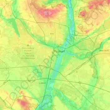
Nom : Carte topographique Poznań, altitude, relief.
Lieu : Poznań, Poznań County, Greater Poland Voivodeship, Poland (52.29192 16.73159 52.50933 17.07171)
Altitude moyenne : 85 m
Altitude minimum : 45 m
Altitude maximum : 146 m
Poznań covers an area of 261.3 km2 (100.9 sq mi), and has coordinates in the range 52°17'34''–52°30'27''N, 16°44'08''–17°04'28''E. Its highest point, with an altitude of 157 m (515 ft), is the summit of Morasko hill within the Morasko meteorite nature reserve in the north of the city. The lowest altitude is 60 m (197 ft), in the Warta valley.
Autres cartes topographiques
Cliquez sur une carte pour visualiser sa topographie, son altitude et son relief.
Kórnik
Poland > Greater Poland Voivodeship > Poznań County
Kórnik, gmina Kórnik, Poznań County, Greater Poland Voivodeship, 62-035, Poland
Altitude moyenne : 75 m
Owińska
Poland > Greater Poland Voivodeship > Poznań County > Owińska
Owińska, gmina Czerwonak, Poznań County, Greater Poland Voivodeship, 62-009, Poland
Altitude moyenne : 74 m
Mosina
Poland > Greater Poland Voivodeship > Poznań County
Mosina, gmina Mosina, Poznań County, Greater Poland Voivodeship, 62-050, Poland
Altitude moyenne : 71 m
Poznań
Poland > Greater Poland Voivodeship > Poznań County
Poznań, Poznań County, Greater Poland Voivodeship, Poland
Altitude moyenne : 85 m