
Carte topographique Beeston
Carte interactive
Cliquez sur la carte pour afficher l’altitude.
À propos de cette carte
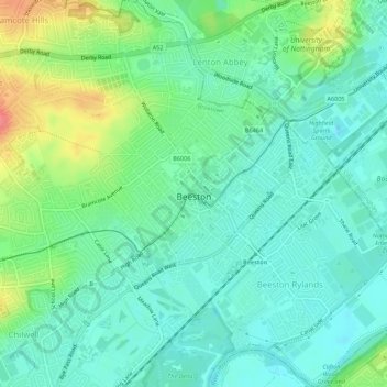
Nom : Carte topographique Beeston, altitude, relief.
Lieu : Beeston, Broxtowe, Nottinghamshire, England, United Kingdom (52.90946 -1.23393 52.94247 -1.18230)
Altitude moyenne : 39 m
Altitude minimum : 19 m
Altitude maximum : 85 m
Autres cartes topographiques
Cliquez sur une carte pour visualiser sa topographie, son altitude et son relief.
Manor House Pond
United Kingdom > England > Nottinghamshire > Broxtowe > Bramcote
Manor House Pond, Bramcote Hills, Bramcote, Broxtowe, Nottinghamshire, England, United Kingdom
Altitude moyenne : 57 m
Nottingham Canal
United Kingdom > England > Nottinghamshire > Broxtowe
Nottingham Canal, Cossall Marsh, Broxtowe, Nottinghamshire, England, NG16 2RU, United Kingdom
Altitude moyenne : 68 m
Attenborough Nature Reserve
United Kingdom > England > Nottinghamshire > Broxtowe
Attenborough Nature Reserve, Tissington Close, Chilwell Meadows Business Park, Chilwell, Broxtowe, Nottinghamshire, England, NG9 6QG, United Kingdom
Altitude moyenne : 34 m
Kimberley
United Kingdom > England > Nottinghamshire > Broxtowe
Kimberley, Broxtowe, Nottinghamshire, England, United Kingdom
Altitude moyenne : 104 m
Cossall
United Kingdom > England > Nottinghamshire > Broxtowe
Cossall, Broxtowe, Nottinghamshire, England, United Kingdom
Altitude moyenne : 70 m
Strelley
United Kingdom > England > Nottinghamshire > Broxtowe > Strelley
Strelley, Broxtowe, Nottinghamshire, East Midlands, England, United Kingdom
Altitude moyenne : 100 m
Nottingham Canal Local Nature Reserve
United Kingdom > England > Nottinghamshire > Broxtowe
Nottingham Canal Local Nature Reserve, Moor Lane, Bramcote Hills, Broxtowe, Nottinghamshire, East Midlands, England, NG9 3GP, United Kingdom
Altitude moyenne : 66 m
Nuthall
United Kingdom > England > Nottinghamshire > Broxtowe
Nuthall, Broxtowe, Nottinghamshire, England, United Kingdom
Altitude moyenne : 95 m
Stapleford
United Kingdom > England > Nottinghamshire > Broxtowe
Stapleford, Broxtowe, Nottinghamshire, England, United Kingdom
Altitude moyenne : 55 m
Giltbrook
United Kingdom > England > Nottinghamshire > Broxtowe
Giltbrook, Broxtowe, Nottinghamshire, England, NG16 2WJ, United Kingdom
Altitude moyenne : 86 m
Stapleford
United Kingdom > England > Nottinghamshire > Broxtowe
Stapleford, Broxtowe, Nottinghamshire, England, United Kingdom
Altitude moyenne : 54 m
Greasley
United Kingdom > England > Nottinghamshire > Broxtowe
Greasley, Broxtowe, Nottinghamshire, England, United Kingdom
Altitude moyenne : 104 m
Eastwood CP
United Kingdom > England > Nottinghamshire > Broxtowe
Eastwood CP, Broxtowe, Nottinghamshire, England, United Kingdom
Altitude moyenne : 81 m
Newthorpe
United Kingdom > England > Nottinghamshire > Broxtowe
Newthorpe, Broxtowe, Nottinghamshire, England, NG16 2AS, United Kingdom
Altitude moyenne : 85 m