
Carte topographique Fel
Carte interactive
Cliquez sur la carte pour afficher l’altitude.
À propos de cette carte
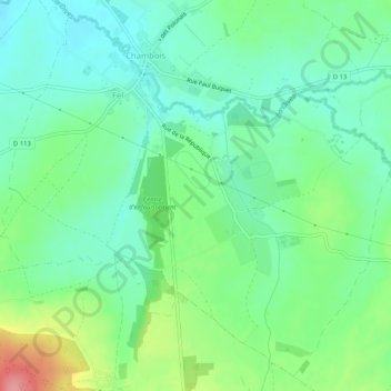
Nom : Carte topographique Fel, altitude, relief.
Altitude moyenne : 123 m
Altitude minimum : 92 m
Altitude maximum : 195 m
Autres cartes topographiques
Cliquez sur une carte pour visualiser sa topographie, son altitude et son relief.
Le Bourg-Saint-Léonard
France > Normandie > Orne > Gouffern en Auge
Le Bourg-Saint-Léonard, Gouffern en Auge, Argentan, Orne, Normandie, France métropolitaine, 61310, France
Altitude moyenne : 168 m
Exmes
France > Normandie > Orne > Gouffern en Auge
Exmes, Gouffern en Auge, Argentan, Orne, Normandie, France métropolitaine, 61310, France
Altitude moyenne : 196 m
Chambois
France > Normandie > Orne > Gouffern en Auge
Chambois, Gouffern en Auge, Argentan, Orne, Normandie, France métropolitaine, 61160, France
Altitude moyenne : 115 m
Urou-et-Crennes
France > Normandie > Orne > Gouffern en Auge
Urou-et-Crennes, Gouffern en Auge, Argentan, Orne, Normandie, France métropolitaine, 61200, France
Altitude moyenne : 184 m
Aubry-en-Exmes
France > Normandie > Orne > Gouffern en Auge
Aubry-en-Exmes, Gouffern en Auge, Argentan, Orne, Normandie, France métropolitaine, 61160, France
Altitude moyenne : 130 m
Silly-en-Gouffern
France > Normandie > Orne > Gouffern en Auge
Silly-en-Gouffern, Gouffern en Auge, Argentan, Orne, Normandie, France métropolitaine, 61310, France
Altitude moyenne : 176 m