
Carte topographique Audubon Society
Carte interactive
Cliquez sur la carte pour afficher l’altitude.
À propos de cette carte
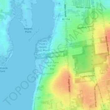
Nom : Carte topographique Audubon Society, altitude, relief.
Altitude moyenne : 14 m
Altitude minimum : -6 m
Altitude maximum : 44 m
Autres cartes topographiques
Cliquez sur une carte pour visualiser sa topographie, son altitude et son relief.
Snake Den
USA > Rhode Island > Johnston
Snake Den, Johnston, Providence, Rhode Island, 02919, USA
Altitude moyenne : 90 m
Beavertail State Park
USA > Rhode Island > Jamestown
Beavertail State Park, Jamestown, Newport, Rhode Island, USA
Altitude moyenne : 2 m
Killingly Pond
USA > Rhode Island > Glocester
Killingly Pond, Dam Road, Glocester, Windham County, Rhode Island, 06243, USA
Altitude moyenne : 193 m
Ninigret National Wildlife Refuge
USA > Rhode Island > Charlestown
Ninigret National Wildlife Refuge, Charlestown, Washington, Rhode Island, USA
Altitude moyenne : 1 m
Narragansett Bay National Estuarine Research Reserve
USA > Rhode Island > Portsmouth
Narragansett Bay National Estuarine Research Reserve, 55, Portsmouth, Newport, Rhode Island, 02872, USA
Altitude moyenne : 10 m
Rhode Island Sound
USA > Rhode Island > Little Compton
Rhode Island Sound, Rhode Island Road, Little Compton, Newport, Rhode Island, 02837, USA
Altitude moyenne : 0 m
Badger Mountain
USA > Rhode Island > Burrillville
Badger Mountain, Burrillville, Providence, Rhode Island, USA
Altitude moyenne : 190 m
Norman Bird Sanctuary
USA > Rhode Island > Middletown
Norman Bird Sanctuary, Middletown, Newport, Rhode Island, 02842, USA
Altitude moyenne : 16 m