
Carte topographique Narayani
Carte interactive
Cliquez sur la carte pour afficher l’altitude.
À propos de cette carte
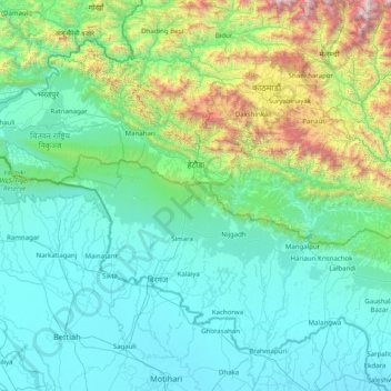
Nom : Carte topographique Narayani, altitude, relief.
Lieu : Narayani, Central Development Region, Nepal (26.74474 83.91936 27.88088 85.51062)
Altitude moyenne : 568 m
Altitude minimum : 59 m
Altitude maximum : 3 976 m
Autres cartes topographiques
Cliquez sur une carte pour visualiser sa topographie, son altitude et son relief.
Chillime
Nepal > Central Development Region > Chillime
Chillime, Rasuwa, Bagmati, Central Development Region, Nepal
Altitude moyenne : 2 194 m
Lantan
Nepal > Central Development Region > Lantan
Lantan, Rasuwa, Bagmati, Central Development Region, Nepal
Altitude moyenne : 5 161 m
Chilime Khola
Nepal > Central Development Region
Chilime Khola, Rasuwa, Bagmati, Central Development Region, Nepal
Altitude moyenne : 2 388 m
Bagmati
Nepal > Central Development Region
Bagmati, Central Development Region, Nepal
Altitude moyenne : 2 279 m
Amlekhganj
Nepal > Central Development Region > Amlekhganj
Amlekhganj, Bara, Narayani, Central Development Region, Nepal
Altitude moyenne : 397 m