
Carte topographique Pasadena
Carte interactive
Cliquez sur la carte pour afficher l’altitude.
À propos de cette carte
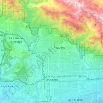
Nom : Carte topographique Pasadena, altitude, relief.
Altitude moyenne : 549 m
Altitude minimum : 142 m
Altitude maximum : 1 852 m
An obscure portion of the Angeles Crest Highway (SR 2) in the San Gabriel Mountains cuts through Pasadena near the Angeles Crest Ranger Station. This 2-mile (3.2 km) stretch of highway in the Angeles National Forest is north of La Cañada Flintridge and west of Mount Wilson and is approximately 3,000 feet (910 m) in elevation.