
Carte topographique Utqiaġvik
Carte interactive
Cliquez sur la carte pour afficher l’altitude.
À propos de cette carte
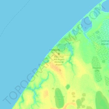
Nom : Carte topographique Utqiaġvik, altitude, relief.
Lieu : Utqiaġvik, North Slope, Alaska, 99273, United States (71.23029 -156.92450 71.34026 -156.63934)
Altitude moyenne : 4 m
Altitude minimum : 0 m
Altitude maximum : 18 m
Despite the extreme northern location, temperatures at Utqiagvik are moderated by the surrounding topography. The Arctic Ocean is on three sides, and flat tundra stretches some 200 mi (320 km) to the south. No wind barriers or protected valleys exist where dense cold air can settle or form temperature inversions in the lower atmosphere, as commonly happens in the interior between the Brooks and the Alaska ranges.[32]
Autres cartes topographiques
Cliquez sur une carte pour visualiser sa topographie, son altitude et son relief.
Prudhoe Bay
United States > Alaska > North Slope
Prudhoe Bay, North Slope, Alaska, 99734, United States
Altitude moyenne : 10 m
Toolik Field Station
United States > Alaska > North Slope
Toolik Field Station, North Slope, Alaska, United States
Altitude moyenne : 740 m
Chandalar Shelf
United States > Alaska > North Slope
Chandalar Shelf, North Slope, Alaska, United States
Altitude moyenne : 974 m
Toolik River
United States > Alaska > North Slope
Toolik River, North Slope, Alaska, United States
Altitude moyenne : 126 m
Kaktovik
United States > Alaska > North Slope > Kaktovik
Kaktovik, North Slope, Alaska, 99747, United States
Altitude moyenne : 5 m
Point Barrow
United States > Alaska > North Slope
Point Barrow, North Slope, Alaska, United States
Altitude moyenne : 0 m
Deadhorse
United States > Alaska > North Slope
Deadhorse, North Slope, Alaska, 99734, United States
Altitude moyenne : 14 m