
Carte topographique Olneyville
Carte interactive
Cliquez sur la carte pour afficher l’altitude.
À propos de cette carte
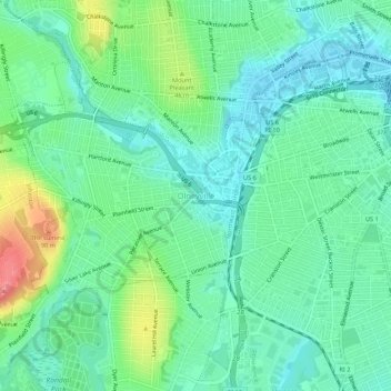
Nom : Carte topographique Olneyville, altitude, relief.
Altitude moyenne : 24 m
Altitude minimum : -1 m
Altitude maximum : 83 m
Autres cartes topographiques
Cliquez sur une carte pour visualiser sa topographie, son altitude et son relief.
Roosevelt Lake
United States > Rhode Island > Providence County > Providence
Roosevelt Lake, Providence, Providence County, Rhode Island, United States
Altitude moyenne : 12 m
Cunliff Pond Dam
United States > Rhode Island > Providence County > Providence
Cunliff Pond Dam, Providence, Providence County, Rhode Island, 02905, United States
Altitude moyenne : 9 m
Providence River
United States > Rhode Island > Providence County > Providence
Providence River, Providence, Providence County, Rhode Island, 02903, United States
Altitude moyenne : 9 m